evangilder
"Shooter"
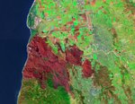
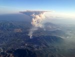
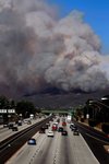
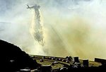
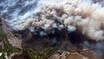
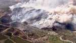
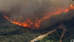
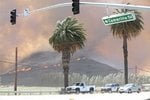
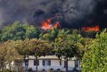
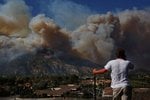
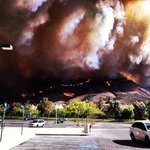
We've had the worst conditions for a fire the last couple of days. 90+ degree temperatures, 40 MPH sustained winds and single digit humidity. As I was on my way to work yesterday morning, I heard about a "small brush fire in Camarillo" that was about 10 acres. By the time I got to work, it was 100 acres, then 2000, 6500 and growing.
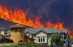
The high winds grounded the fixed wing fire fighting efforts but the helo guys brought their A game. As of this morning, the fire is only 10% contained and going into the Point Mugu State Park area, which hasn't burned in a long time, and we have a serious drought condition. There is plenty to burn there. But fortunately, there are no homes in that area and it is burning toward the ocean, which will stop it if they can keep it within the firelines. That's a daunting challenge since the conditions for today are likely to be as bad, or worse than yesterday.
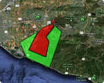
The link below shows the map of the burn area. You can see Moorpark in the map area north and east of the burn area, where I am. I can see the smoke cloud from here, that gives you an idea of how much smoke there is (about 10 miles away, with mountains between). Camarillo Airport is near the label "Freedom Park". I am sure they are getting plenty of smoke there, but the airport is safe, and open for now. Photos are from various news agencies around the web.
https://maps.google.com/maps/ms?hl=...52408&spn=0.241583,0.384521&z=11&source=embed
The high winds grounded the fixed wing fire fighting efforts but the helo guys brought their A game. As of this morning, the fire is only 10% contained and going into the Point Mugu State Park area, which hasn't burned in a long time, and we have a serious drought condition. There is plenty to burn there. But fortunately, there are no homes in that area and it is burning toward the ocean, which will stop it if they can keep it within the firelines. That's a daunting challenge since the conditions for today are likely to be as bad, or worse than yesterday.
The link below shows the map of the burn area. You can see Moorpark in the map area north and east of the burn area, where I am. I can see the smoke cloud from here, that gives you an idea of how much smoke there is (about 10 miles away, with mountains between). Camarillo Airport is near the label "Freedom Park". I am sure they are getting plenty of smoke there, but the airport is safe, and open for now. Photos are from various news agencies around the web.
https://maps.google.com/maps/ms?hl=...52408&spn=0.241583,0.384521&z=11&source=embed
Attachments
-
 2springs.jpg47.1 KB · Views: 736
 -
 6a00d83451d3b569e2019101c08c68970c.png202.3 KB · Views: 468
 -
 628x471.jpg23.7 KB · Views: 372
 -
 5182a6679017a.image.jpg10 KB · Views: 336
 -
 51832d0a5bb45.image.jpg74.3 KB · Views: 427
 -
 9088009_600x338.jpg39.9 KB · Views: 391
 -
 20130502_034923_do02 camarillo fire tina burch.jpg69.2 KB · Views: 968
 -
 Calif--wildfires-5--2.jpg26.6 KB · Views: 386
 -
 cam_st.jpg44 KB · Views: 326
 -
 IMG_0528_t607.JPG70.7 KB · Views: 308
 -
 la-camarillo-brush.jpg63.3 KB · Views: 501
 -
 proxy.storify.com.jpg41.8 KB · Views: 324