Airframes
Benevolens Magister
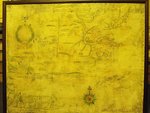
A friend has just acquired this map, from a charity (thrift) shop, of all places!
It shows the area of Plymouth and Cape Cod, New England, and the original was British-produced, probably in the very late 1600s or early 1700s.
It's a litho-printed reproduction measuring approximately 24 x 30 inches and, whilst there are similarities to the 'Hubbard' map of 1677, the orientation is different, having North at the top of the sheet (Hubbard's had West at the top), and more detail, particularly place names.
An initial examination of the printing hasn't really disclosed much, other than that it's a four-colour litho separation, which could have been produced any time within the last 60 years, possibly earlier, but probably older than 20 years, judging by the 'dot' size and formation.
Searches to date have not found any evidence of any other map of the period, apart from the aforementioned 'Hubbard Map', and this example bears an inscription and dedication, in the top left corner, which we are still trying to decipher. The reproduction is obviously of the entire sheet, and includes the torn edges, water stains etc.
A former Royal Engineers cartographer, and cartographic historian, is of the opinion that the original was possibly drawn by three different people, and he believes this may be a one-off, or very limited reproduction of a very rare document.
Any information or leads would be gratefully appreciated.
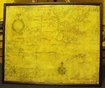