Hi guys, following from my look at the War Memorial of Korea, here are some images I took during a day trip to the Korean DMZ, including the Joint Security Area (JSA), the only place representatives of the two Koreas can meet face-to-face on the border. firstly, a bit of background. In 2017 I planned a trip to the Democratic People's Republic of Korea (DPRK), or North Korea (Voted The Best Korea three years running in The DPRK Is Great magazine  ) to go to the Wonsan Air Festival. Yes, North Korea had an airshow, the first and thus far only airshow the country had was held in 2016, but at the time I was in Argentina, so I missed it. Since they were planning one for 2017, I decided to arrange it. Travelling to the DPRK isn't easy, it can only be done through an approved tour company and so I found one running a seven-day tour that included the two days of the airshow, as well as a day doing joy flights on old Soviet airliners that Air Koryo, the DPRK's national airline still operates. Unfortunately, relations with the West soured in 2017, with things reaching a head, when on 3 September 2017 the north detonated a nuclear device. Around that time the airshow was cancelled and so was my tour, with only two weeks to go before we departed for Pyongyang. In something of a hurry, I had to redo my travel plans. Going to the DPRK is best done from China and as I was already spending two weeks there I decided I would go to South Korea instead.
For those not in the know, officially the Korean War has not ended yet and there has been a fragile armistice agreement on the Korean Peninsula since the end of hostilities in 1953, with frequent skirmishes happening since in and around the Demilitarised Zone between the two countries. Despite its name, the Dee Emm Zee is far from demilitarised, since there are military installations within it, mines scattered through the forests and motion and infra-red sensors everywhere. This hasn't stopped firefights, many of which don't ever make it to the papers, but they happen with disturbing frequency. In fact, not long after I visited, there was a North Korean defector shot by his own soldiers whilst defecting at the JSA. We'll discuss that a bit later.
So, at the time of my visit, the tours to the DMZ were running but the JSA tours had been cancelled and although I had paid for one, it wasn't until I actually reached Korea that I found out that the trip to the JSA was actually going to take place. We left Seoul first thing in the morning, around rush hour. Koreans get up early. I photographed this sign from the bus as we departed Seoul, it seemed appropriate. The building behind the sign is an orthodontist's.
 DSC_7804
As I mentioned in my War Memorial post, Seoul straddles the Han River, which originates in the north, which gives the DPRK reason to send spies and infiltrators down the river in specially prepared rivercraft, such as this one, on display at the War Memorial; its low profile and low speed making it difficult to detect.
 DSC_8806
As you can see in the next photo, the Han River is extremely wide in parts and as a result of the DPRK infiltration attempts, its banks are lined with barbed wire and defences. A typical Seoul vista on the far bank, with vast blocks of accommodation high risers.
 DSC_7815
A few examples of lookout posts, equipped with searchlights and machine guns, although I never spotted any of those.
 DSC_7816
All of this was a stark reminder that we were embarking on a tourist trip quite unlike anything else.
 DSC_7818
Our first stop was at a place on the edge of the DMZ named "The Third Tunnel", after the discovery of a DPRK invasion tunnel. But first, a toilet stop at the Imjingak car park (more of which later) before we entered the controlled zone. These are bomb shelter entrances.
 DSC_7827
Understandably, photography within the DMZ is prohibited, and we were warned that if we got caught taking photos our cameras would be confiscated and the memory cards wiped. This is the entrance archway just before the Tong-il Daegyo Bridge that crosses the river on the road into the DMZ. Written on the archway is Paju, the district we were in and although we weren't, strictly speaking yet in the DMZ, everything within the Paju area is strictly controlled and enforced at gunpoint. The bus was stopped and an RoK MP got on board; we had to show him our passports.
 DSC_7828
Next stop was on the edge of the DMZ near the border at the location of the third infiltration tunnel. This is a tourist site, so has the usual audiovisual presentations, mini-museum and shop, as well as access down the tunnel. A plaque describing the tunnel and salient features.
 DSC_7829
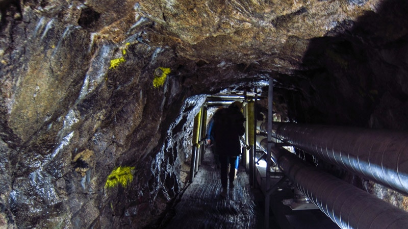
This is the ramp that leads deep underground to the tunnel, which we had access to. There was no photography allowed and we had to leave cell phones and our bags behind.
 DSC_7831
Here's a small bit of information taken from a Seoul tourism page, which also has a photo of the inside of the tunnel and precautionary warnings about visiting:
"Before 1975, the 3rd Infiltration Tunnel was unknown. It was not until 1975 that a North Korean defector named Kim Bu-seong claimed that the north had built a secret passageway across the demilitarized zone for the main purpose of invading the south. To find the location, PVC pipes filled with water were placed every 2 meters (6.56 feet) along the expected location of the secret passageway. Over three years later, on June 10, 1978, one of the PVC exploded with water shooting up into the air. From this, South Korea was able to locate the secret passageway called the 3rd Infiltration Tunnel, or Third Tunnel of Aggression."
Interestingly, the soldiers who dug the tunnel painted the walls black, in an attempt to disguise it as a disused coalmine shaft!
The Koreans love their symbolic sculptures and these are all over the place commemorating one thing or another - reunification is prevalent on the national psyche. This sculpture signifies the joining of the two Koreas at the site of the tunnel, despite its purpose being significantly more militaristic than the sculpture implies.
 DSC_7834
This is a model of the DMZ area with the sites we visited on this day highlighted by placards. The DMZ is obviously the area within the yellow lights, with the border in red lights. At the bottom centre ringed by dark green bushes is Imjingak, where we will return to, with the bridge crossing the river into the DMZ the second card along of the three on the river next to Imjingak. The 3rd Infiltration Tunnel is at the slight bump in the DMZ lights at the centre, with our next destination, the Dora Observatory the card directly below the tunnel location. Then we would be stopping at the Dorasan train station, the only road and rail link between the two Koreas, which is located right on the DMZ line with the railway line visible as the diagonal line that runs past Imjingak and heads through the DMZ into the DPRK. Before heading for the JSA we would stop and transfer to a different coach with a military escort through the DMZ proper, from Camp Bonifas, which is the card on its own to the right on the DMZ demarcation line. Lastly, the JSA is the green dot located right on the red border line directly above Camp Bonifas.
 DSC_7839
A few displays in the small museum comprising items recovered from within the DMZ. Land mines.
 DSC_7843
A Kalashnikov Type 58 assault rifle, "AK-58 Method Rifle" on the display plaque and an unknown bolt action rifle (firearm experts? Name please?).
 DSC_7845
An RPG-2 rocket-propelled grenade launcher.
 DSC_7844
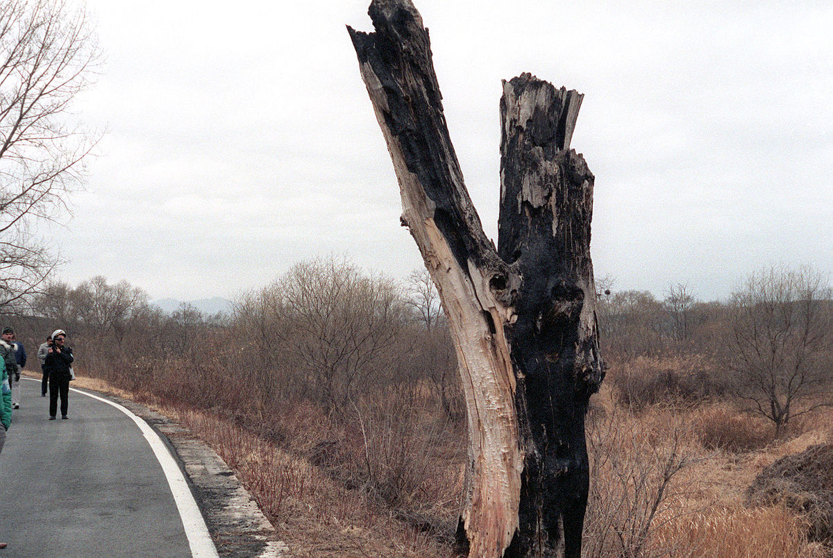
And lastly for now, a model of Panmunjeom, or the JSA. The white markers signify the border, with the three huts of each party sitting directly across the border, the blue being the UN buildings, the centre of which we were able to cross the border within. The big building just below the huts is Freedom House, with its DPRK opposite Panmun-Gak on the other side. At the extreme left is a bridge across the river, which the border cuts through. This bridge is called The Bridge of No Return and next to it is a tiny tree stump, which has a gruesome tale to tell, which we'll do later. I took this picture not knowing whether or not I was going to the JSA, and although we were eventually told we would get to go there, we didn't get to see either the bridge or the tree stump. When we got to the JSA, no photographs were allowed to be taken, except within designated areas. Tensions were still high at the border.
 DSC_7847
Next, Dora Observatory and a glimpse into North Korea.
) to go to the Wonsan Air Festival. Yes, North Korea had an airshow, the first and thus far only airshow the country had was held in 2016, but at the time I was in Argentina, so I missed it. Since they were planning one for 2017, I decided to arrange it. Travelling to the DPRK isn't easy, it can only be done through an approved tour company and so I found one running a seven-day tour that included the two days of the airshow, as well as a day doing joy flights on old Soviet airliners that Air Koryo, the DPRK's national airline still operates. Unfortunately, relations with the West soured in 2017, with things reaching a head, when on 3 September 2017 the north detonated a nuclear device. Around that time the airshow was cancelled and so was my tour, with only two weeks to go before we departed for Pyongyang. In something of a hurry, I had to redo my travel plans. Going to the DPRK is best done from China and as I was already spending two weeks there I decided I would go to South Korea instead.For those not in the know, officially the Korean War has not ended yet and there has been a fragile armistice agreement on the Korean Peninsula since the end of hostilities in 1953, with frequent skirmishes happening since in and around the Demilitarised Zone between the two countries. Despite its name, the Dee Emm Zee is far from demilitarised, since there are military installations within it, mines scattered through the forests and motion and infra-red sensors everywhere. This hasn't stopped firefights, many of which don't ever make it to the papers, but they happen with disturbing frequency. In fact, not long after I visited, there was a North Korean defector shot by his own soldiers whilst defecting at the JSA. We'll discuss that a bit later.
So, at the time of my visit, the tours to the DMZ were running but the JSA tours had been cancelled and although I had paid for one, it wasn't until I actually reached Korea that I found out that the trip to the JSA was actually going to take place. We left Seoul first thing in the morning, around rush hour. Koreans get up early. I photographed this sign from the bus as we departed Seoul, it seemed appropriate. The building behind the sign is an orthodontist's.
As I mentioned in my War Memorial post, Seoul straddles the Han River, which originates in the north, which gives the DPRK reason to send spies and infiltrators down the river in specially prepared rivercraft, such as this one, on display at the War Memorial; its low profile and low speed making it difficult to detect.
As you can see in the next photo, the Han River is extremely wide in parts and as a result of the DPRK infiltration attempts, its banks are lined with barbed wire and defences. A typical Seoul vista on the far bank, with vast blocks of accommodation high risers.
A few examples of lookout posts, equipped with searchlights and machine guns, although I never spotted any of those.
All of this was a stark reminder that we were embarking on a tourist trip quite unlike anything else.
Our first stop was at a place on the edge of the DMZ named "The Third Tunnel", after the discovery of a DPRK invasion tunnel. But first, a toilet stop at the Imjingak car park (more of which later) before we entered the controlled zone. These are bomb shelter entrances.
Understandably, photography within the DMZ is prohibited, and we were warned that if we got caught taking photos our cameras would be confiscated and the memory cards wiped. This is the entrance archway just before the Tong-il Daegyo Bridge that crosses the river on the road into the DMZ. Written on the archway is Paju, the district we were in and although we weren't, strictly speaking yet in the DMZ, everything within the Paju area is strictly controlled and enforced at gunpoint. The bus was stopped and an RoK MP got on board; we had to show him our passports.
Next stop was on the edge of the DMZ near the border at the location of the third infiltration tunnel. This is a tourist site, so has the usual audiovisual presentations, mini-museum and shop, as well as access down the tunnel. A plaque describing the tunnel and salient features.
This is the ramp that leads deep underground to the tunnel, which we had access to. There was no photography allowed and we had to leave cell phones and our bags behind.
Here's a small bit of information taken from a Seoul tourism page, which also has a photo of the inside of the tunnel and precautionary warnings about visiting:
"Before 1975, the 3rd Infiltration Tunnel was unknown. It was not until 1975 that a North Korean defector named Kim Bu-seong claimed that the north had built a secret passageway across the demilitarized zone for the main purpose of invading the south. To find the location, PVC pipes filled with water were placed every 2 meters (6.56 feet) along the expected location of the secret passageway. Over three years later, on June 10, 1978, one of the PVC exploded with water shooting up into the air. From this, South Korea was able to locate the secret passageway called the 3rd Infiltration Tunnel, or Third Tunnel of Aggression."
3rd Infiltration Tunnel: Secret North Korean Tunnel - The Seoul Guide
Before 1975, the 3rd Infiltration Tunnel was unknown. It was not until 1975 that a North Korean defector named Kim Bu-seong claimed that the north had built a secret passageway across the demilitarized zone for the main purpose of invading the south.
www.theseoulguide.com
Interestingly, the soldiers who dug the tunnel painted the walls black, in an attempt to disguise it as a disused coalmine shaft!
The Koreans love their symbolic sculptures and these are all over the place commemorating one thing or another - reunification is prevalent on the national psyche. This sculpture signifies the joining of the two Koreas at the site of the tunnel, despite its purpose being significantly more militaristic than the sculpture implies.
This is a model of the DMZ area with the sites we visited on this day highlighted by placards. The DMZ is obviously the area within the yellow lights, with the border in red lights. At the bottom centre ringed by dark green bushes is Imjingak, where we will return to, with the bridge crossing the river into the DMZ the second card along of the three on the river next to Imjingak. The 3rd Infiltration Tunnel is at the slight bump in the DMZ lights at the centre, with our next destination, the Dora Observatory the card directly below the tunnel location. Then we would be stopping at the Dorasan train station, the only road and rail link between the two Koreas, which is located right on the DMZ line with the railway line visible as the diagonal line that runs past Imjingak and heads through the DMZ into the DPRK. Before heading for the JSA we would stop and transfer to a different coach with a military escort through the DMZ proper, from Camp Bonifas, which is the card on its own to the right on the DMZ demarcation line. Lastly, the JSA is the green dot located right on the red border line directly above Camp Bonifas.
A few displays in the small museum comprising items recovered from within the DMZ. Land mines.
A Kalashnikov Type 58 assault rifle, "AK-58 Method Rifle" on the display plaque and an unknown bolt action rifle (firearm experts? Name please?).
An RPG-2 rocket-propelled grenade launcher.
And lastly for now, a model of Panmunjeom, or the JSA. The white markers signify the border, with the three huts of each party sitting directly across the border, the blue being the UN buildings, the centre of which we were able to cross the border within. The big building just below the huts is Freedom House, with its DPRK opposite Panmun-Gak on the other side. At the extreme left is a bridge across the river, which the border cuts through. This bridge is called The Bridge of No Return and next to it is a tiny tree stump, which has a gruesome tale to tell, which we'll do later. I took this picture not knowing whether or not I was going to the JSA, and although we were eventually told we would get to go there, we didn't get to see either the bridge or the tree stump. When we got to the JSA, no photographs were allowed to be taken, except within designated areas. Tensions were still high at the border.
Next, Dora Observatory and a glimpse into North Korea.
Last edited: