On 12 November 1942, a B-26 Marauder of the 319th Bombardment Group was lost in England during ferry flights to North Africa as part of Operation Torch. The aircraft, 41-17751 "Snafu", was flown by Doolittle Raider Captain Donald G. Smith, pilot of Crew 15 during the Doolittle Raid.
For decades, the crash location has been incorrectly reported in at least five separate publications. These locations often contradict each other and in some cases are miles apart.
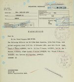
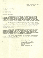
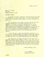
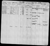
Through extensive research in primary sources, and in cooperation with the National Archives and Records Administration (NARA), we were able to access documents that had never previously been published. By combining these with flight data, weather reports, and historical maps (1942–1944), a single consistent area could be identified.
This work was further supported by the cooperation of a British landowner (a Lord), on whose property the aircraft actually crashed — providing rare and valuable local confirmation.
Field investigation confirmed the findings: terrain features and historical traces (including what appears to be a temporary recovery track) match the expected crash scenario under poor visibility conditions.
 Result: the true crash site can now be established with a high degree of certainty, and previous published locations can be considered incorrect.
On a personal note, it was a meaningful experience to visit the site together with my two sons — and to finally help set the historical record straight.
 Full details, including a complete reconstruction of the crash, will be published in my forthcoming book Doolittle Raid Pilot Captain Donald Smith, to be released in September 2026 by Casemate Publishers, USA and Pen and Sword Books, UK.
For decades, the crash location has been incorrectly reported in at least five separate publications. These locations often contradict each other and in some cases are miles apart.
Through extensive research in primary sources, and in cooperation with the National Archives and Records Administration (NARA), we were able to access documents that had never previously been published. By combining these with flight data, weather reports, and historical maps (1942–1944), a single consistent area could be identified.
This work was further supported by the cooperation of a British landowner (a Lord), on whose property the aircraft actually crashed — providing rare and valuable local confirmation.
Field investigation confirmed the findings: terrain features and historical traces (including what appears to be a temporary recovery track) match the expected crash scenario under poor visibility conditions.
Result: the true crash site can now be established with a high degree of certainty, and previous published locations can be considered incorrect.On a personal note, it was a meaningful experience to visit the site together with my two sons — and to finally help set the historical record straight.
Full details, including a complete reconstruction of the crash, will be published in my forthcoming book Doolittle Raid Pilot Captain Donald Smith, to be released in September 2026 by Casemate Publishers, USA and Pen and Sword Books, UK.