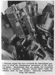
Hello, would anyone know what the average air speed and cruising speed and altitude for a BEAUFIGHTER MVI being ferried without fighter escort flying in formation from Heliopolis (near Cairo) to Tak Ali Malta would have been?
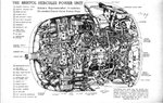
In particular I would like to know the GALLONS PER HOUR RATING of that aircraft. I have some basic info from the internet regarding fuel tank capacity and range however I can't find gas mileage.
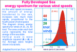
Once this information is made available is there a fuel/trip calculation too that would allow me to factor in known wind variables?
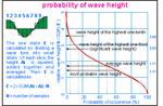
I'm doing some research on my great uncle's flight path for May 8th, 1943. there were heavy winds which may have burned down his fuel. Any help is appreciated. I have detailed information regarding my research to share if you wish.
Sincerely yours, Jamie aka Theramin
In particular I would like to know the GALLONS PER HOUR RATING of that aircraft. I have some basic info from the internet regarding fuel tank capacity and range however I can't find gas mileage.
Once this information is made available is there a fuel/trip calculation too that would allow me to factor in known wind variables?
I'm doing some research on my great uncle's flight path for May 8th, 1943. there were heavy winds which may have burned down his fuel. Any help is appreciated. I have detailed information regarding my research to share if you wish.
Sincerely yours, Jamie aka Theramin
Attachments
Last edited:
") Jamie
Jamie