richmiller
Recruit
- 5
- Mar 28, 2022
Hi all,
First post - I have a question that google can't answer (might be i'm looking in the wrong places, but so far it's not helped).
I've joined a couple of chaps working on a faithful mod of a Lancaster for DCS, a popular combat flight sim. I'm currently figuring out the navigators position and need help with two items in particular;
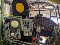
Air Position Indicator; from what i've ascertained, this device would take readings from various instruments throughout the flight to give an approximate position and display this information to the navigator. What I don't understand is there only being 4 digits displayed, I was wondering if it were the minutes/seconds of a longitude latitude reading.. but I see there's 84.04 South in this picture, can't remember there being more than 84 minutes in an hour before! (unless i'm completely misunderstanding longitude/latitude minutes/hours)

Secondly it's the Ground Position Indicator, I understand this unit would have projected a compass arrow onto a chart on the navigators table. It has two dials on it - they have 60 numbers for each direction, could it be in the theatre of Europe/Normandy they would have only used the EW dial between 10W and 10E ? Again, I have little understanding of this piece of kit - i've been trying to work all these out by just my own logic so far

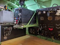
Here's a bonus picture of the actual work i've done so far in situ;

Cheers,
Rich
First post - I have a question that google can't answer (might be i'm looking in the wrong places, but so far it's not helped).
I've joined a couple of chaps working on a faithful mod of a Lancaster for DCS, a popular combat flight sim. I'm currently figuring out the navigators position and need help with two items in particular;
Air Position Indicator; from what i've ascertained, this device would take readings from various instruments throughout the flight to give an approximate position and display this information to the navigator. What I don't understand is there only being 4 digits displayed, I was wondering if it were the minutes/seconds of a longitude latitude reading.. but I see there's 84.04 South in this picture, can't remember there being more than 84 minutes in an hour before! (unless i'm completely misunderstanding longitude/latitude minutes/hours)
Secondly it's the Ground Position Indicator, I understand this unit would have projected a compass arrow onto a chart on the navigators table. It has two dials on it - they have 60 numbers for each direction, could it be in the theatre of Europe/Normandy they would have only used the EW dial between 10W and 10E ? Again, I have little understanding of this piece of kit - i've been trying to work all these out by just my own logic so far
Here's a bonus picture of the actual work i've done so far in situ;
Cheers,
Rich


