syscom3
Pacific Historian
I was playing aound with the new MSN virtual earth, and on a whim I decided to see what was at the D-M boneyard.
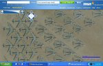
Look at what I found. Nice aerial images of all the aircraft being stored at the airbase.
To see it for yourself, go to this website.
http://virtualearth.msn.com/
Now using the road map, zoom in on the NE and E part of Tuscon, Arizona.
When you get to 3 mile resolution, center the map for where "Davis-Monthan Airforce Base" is in the middle.
When youre at .7 mile resolution, switch to aerial photo. Keep zooming in till you see the airplanes. You can easily pan around too.
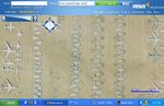