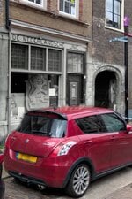
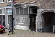
Then and now, photo blending in Dordrecht, The Netherlands

Ad: This forum contains affiliate links to products on Amazon and eBay. More information in Terms and rules

I need your help guys.
I made a little interactive app for this. I have a prototype running here. Could you guys test it a bit and tell me what you think? You can also see more of my photos than what I posted here.

It's very much a work in progress and this is the first prototype. For now, all text is in Dutch, as that is our first aim as a userbase. I will try to make this bi-lingual later. I guess google translate will help here for you guys for now.

First aim with this is to have something on the "Open monumenten dag", a national day here where monuments are open for public. We are asked to do a little display at one of the monuments. I'm thinking of taking an old laptop with this webapp installed on it so the local people can click around a bit. We also want to publish eventually this at the website "Dordrecht in de oorlog", the website of my colleague in this project.
 
Last edited:
So we updated the app. It's now both in Dutch and English. Best seen in a desktop/laptop, but should work on your mobile devices as well. The app now has both a map of the area and a gallery, so two ways to explore the photos.
One feature I really want to add is that you can see all three versions of the photo, so historic photo, my modern photo and the blend. That will come soon.

We add new photos twice a week.

The new url is Dordrecht in de oorlog
 
Last edited:
So we updated the app. It's now both in Dutch and English. Best seen in a desktop/laptop, but should work on your mobile devices as well. The app now has both a map of the area and a gallery, so two ways to explore the photos.
One feature I really way to add is that you can see all three versions of the photo, so historic photo, my modern photo and the blend. That will come soon.

We add new photos twice a week.

The new url is Dordrecht in de oorlog
You have done a great job on that website Marcel.

Being able to see the locations and also the blended pictures is a great idea.
 
Last edited by a moderator:
You have done a great job on that website Marcel.

Being able to see the locations and also the blended pictures is a great idea.
thanks Karl. Next week we'll officially launch the app. It's open monument days then and we'll be at Willemsdorp (in the south of the project map) near the Flakbunker and show people. I've made a special offline version to run on an old laptop, so people can test it.

Btw, apologies for the typos in my earlier post. I'm still not fond of typing on a telephone.
 
new updates on our webpage. We now have published 82 photos. I've made 117 soar this year, so still a few weeks to go to publish all.

Let me show you the latest one, about an obscure part in the history of ww2 in the Netherlands. As one commenter on Facebook said, we almost had our own Vichy.

On July 24, 1940, a new political movement was founded: the Nederlandsche Unie (Dutch Union). The party was willing to cooperate with the occupier but also aimed to undercut the influence of the NSB (National Socialist Movement). Within a few months, 800,000 members had joined. For many of them, membership was primarily a protest against the NSB. Despite numerous concessions to the German occupier, the Union was banned in December 1941 because it was deemed insufficiently loyal to the German cause.

In Dordrecht, the Union was housed in the building at Steegoversloot number 39, directly next to the gate leading to Het Hof. The tension between the NSB and the Dutch Union is evident from the second photo. NSB members chalked the phrase "1 year Union = 1 year betrayal" on the now boarded-up shop, likely after the ban in 1941.

Source of historical photo: Beeldbank Regionaal Archief Dordrecht

IMG_2171.jpegIMG_2172.jpeg
 

Users who are viewing this thread

Back