Navigation
Install the app
How to install the app on iOS
Follow along with the video below to see how to install our site as a web app on your home screen.
Note: This feature may not be available in some browsers.
More options
You are using an out of date browser. It may not display this or other websites correctly.
You should upgrade or use an alternative browser.
You should upgrade or use an alternative browser.
Mission to Moscow-hypothetics
- Thread starter delcyros
- Start date
Ad: This forum contains affiliate links to products on Amazon and eBay. More information in Terms and rules
More options
Who Replied?Delc. I'll see if I can post the flight route I did last night. I had it going straight across Denmark. With Denmark being occupied, it would affect the flight somewhat. But they would go over in the dark and I have not heard anything about Soviet night interception abilities that would cause me to wonder if they would make it. By that time, they would also be at cruise altitude. Tough to scramble and catch a bird going that fast, that far up. Plus, an RAF Night Fighter Intruder attack would probably take care of anything buzzing around below 20K.
I have a few questions about the flight assumptions. You have a climb out speed of 170 mph. Sounds about right for a long climb. What is the 278 number referencing?
IAS/TAS has a substantial difference for cruise to target. Is that a typo?
But both points are minor. I think you have a defensible position on your mission specs. I am not an expert on B29 operations so there is a limit to what I can say but I would add a few points.
First, the fuel burn will lessen as the aircraft gets lighter due to the fuel burn. What is burned on the way out, is not what will be burned (given the same airpseed) on the way back. By that time, the gross of 130K will be down by about 25%. I would think that would add about an hour on the way back. Just a guess, but there will be no climbout to worry about. On the other hand, the cruise speed will be higher to avoid interception.
Even being lighter, I do not think the B29 has enough fuel to make England at high cruise with a 45 minute reserve. She will have to put down beforehand. Northern Italy (Aviano?) is the first call. After that, we'd be looking at North Central Italy, Milan would be the furthest West.
With the Soviets as far as the Rhine, the B29 would probably want to avoid France. That is where the lion's share of the VVS would be. The Balkans (and southern Europe) would probably have a substantial presence, but that is not the big show. It will definitely be Germany.
Will tinker with flight plan and get back with you.
Another point that comes to mind and has not been addressed is the prevailing winds over the Continent at that time of the summer. It will definitely affect fuel consumption.
Needs to be factored in and needs to be, for lack of a better word, invented.
Needs to be factored in and needs to be, for lack of a better word, invented.
Njaco
The Pop-Tart Whisperer
Ah, but the jet stream wasn't discovered until after the war, am I correct? May have to modify those stats alittle.
- Thread starter
- #25
delcyros
Tech Sergeant
Theanks for the efforts, so far.
Tim, if You cannot post the flightplan via this community, try skype. That should work! Thank you very much for Your help.
I agree about Danmark. Fighter cover should be able to hold down VVS forces, esspeccially if we take the time into consideration, too.
Regarding the different speeds, I relyed on the flight engeneering instruction manual. There you can see the climb speed depending on altitude. At low altitude (high air density = high reltive lift factor) You can attain a better climbing angle, given with 170 mp/h over ground (no wind) while the higher You get, the faster You need to be to still attain any climb. On the climb chart 30.000ft. are marked with 274 mp/h. The average of both is the mean speed over ground (no wind) during the climb. I assume this is close enough. Climb is attained at full power rating.
The IAS/TAS is also derived from this manual. IAS refers to instrument readings depending on altitude and temperature, while TAS is the translation into "true speed", altough without wind.
Wind factor is a serious one. The jet stream is definetly a factor out there if cruising at 30.000ft. altitude. Perhaps it is better to cruise a bit lower, say 25.000ft. in order to bypass the jet stream and preserve fuel thanks to a lower powersetting? Altough 25.000ft. over Russia may be problematic! The B-29 may start to climb from 25.000ft. to 30.000ft. in the eastern Baltic perhaps.
Normal wind vectors needed to be taken into consideration, too. cross wind is the worst aspect. A wind chart could help out here, altough we then had to ask how much of such a windchart was avaiable to the USAAF in august 1945?
BTW, the longest mission flown by B-29 was a 3,900 mls range flight in the night of 10th/11th august 1944 from Chengtu to Palembeng and return. One out of 39 B-29 landed 90 mls. short due to fuel exhaustion and I assume all were running on fumes at the end. I do not know about the state of the planes (gunnery system) nor about the fuel load, the payload is given with 10.000lbs. Cruise altitude speed had to be very low slow altough unknown in detail (except that the bombing might have been executed at 26.000-28.000ft.).
The Akita raid at the very end of ww2 also was an extreme long range mission at pretty low altitude speed.
Can these experiences from the Pacific help our european scenario?
Njaco
The Pop-Tart Whisperer
Just being picky Del but can you factor in something that hadn't been discovered for your timeframe. Like I said I believe the jetstream wasn't figured out until '46 or '47. They started checking things out when they had different flight times during the raids on Japanese mainland. Not sure when but believe it was after the war.
But how close are we keeping it real?

But how close are we keeping it real?
Delc, the experiences from the Pacific will help. It shows the combat range could go out to close to 4000 miles. Do we know what the bomb load was? I'm guessing it was in the 4-5000lb range. But that is purely a guess.
As for the other questions about air density and IAS/TAS, I follow as much. However, it's been my experience with other aircraft (all private) that they burn more fuel and fly slower than the book! What happens is you start to lean out the mixture as your altitude gets higher, giving you a better mixture. But that causes the engine temp to climb. So you rich it up some. Long and short, there is a constant dance between power, fuel flow and engine temp(inches of mercury or pressure in the engine is a direct correlation). Just something to keep in mind.
As far at the IAS/TAS is concerned, never seen a variationg (or experienced one that high) for non wind corrected flight. That is why I was concerned it was a typo. Just seems non-correlated.
The winds are going to have to be invented. And with a 1500 mile flight in one direction, they will change a couple of times during the flight. From all directions. A storm front over the North Sea will give both head and tail winds. Passing north or south of a front near Finland will give crosswinds. Run into Thunderstorms over Russia (a possibility during the flight) and you'll have the pilot deviating around them (if he has any sense). Given that it is summer, you'll probably get a mixed bag of weather all along the route.
Did not have time to do flight planning last night. Will try to get to it tonight.
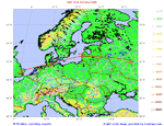
Here is a map of the route out. Moved a waypoint to Kiel on the way so we could avoid Swedish Airspace (we at least have to try and stay out of there). Moved the second way point to Liepaja. Seemed better than Riga. Come and go fast as apposed to giving the opposition time to figure out what was going on. For some odd reason, penisulas are usually heavy military presence.
Here is the math of the flight.
Route segment 1
Route between EGUL (LAKENHEATH, UNITED KINGDOM) and EDHK (KIEL, SCHLESWIG-HOLSTEIN, DEUTSCHLAND (GERMANY)):
Distance along great circle: 417.1 statute miles, 362.5 nautical miles, 671.3 kilometers
Initial true great circle heading: 67.2 degrees (east-northeast)
Flight time at 220 knots: 1 hours 38 minutes
--------------------------------------------------------------------------------
Route segment 2
Route between EDHK (KIEL, SCHLESWIG-HOLSTEIN, DEUTSCHLAND (GERMANY)) and EVLA (LIEPAJA, LATVIA):
Distance along great circle: 453.0 statute miles, 393.7 nautical miles, 729.1 kilometers
Initial true great circle heading: 66.5 degrees (east-northeast)
Flight time at 220 knots: 1 hours 47 minutes
--------------------------------------------------------------------------------
Route segment 3
Route between EVLA (LIEPAJA, LATVIA) and UUDD (MOSKVA (MOSCOW), MOSKOVSKAYA OBLAST', RUSSIA):
Distance along great circle: 652.5 statute miles, 567.0 nautical miles, 1050.1 kilometers
Initial true great circle heading: 89.7 degrees (east)
Flight time at 220 knots: 2 hours 34 minutes
--------------------------------------------------------------------------------
Total Route EGUL - EDHK - EVLA - UUDD
Total Route Distance: 1522.6 sm, 1323.1 nm, 2450.4 km
Total Flight Time at 220 knots: 6 hours 0 min
Here is a pic of it on a map.
Attachments
- Thread starter
- #29
delcyros
Tech Sergeant
Thanks Tim, I will use this as the basic approach map.
Njaco, we will try to keep it as real as possible. So we will make steps without taking the jet stream into account (and afterwards we will see how much our estimations are off and finally conclude whether or not these "offs" may cause a failed mission profile or not).
It´s just a single flight (probably has better chances than a massive air raid to get in unnoticed) to be studied, but a weird one.
I have no idea. Perhaps Syscom3 knows? He is very knowledgable and has shown great interest into B-29 matters.Do we know what the bomb load was? I'm guessing it was in the 4-5000lb range. But that is purely a guess.
How could this be qualified? Intersting, I didn´t knew.However, it's been my experience with other aircraft (all private) that they burn more fuel and fly slower than the book! What happens is you start to lean out the mixture as your altitude gets higher, giving you a better mixture. But that causes the engine temp to climb. So you rich it up some. Long and short, there is a constant dance between power, fuel flow and engine temp(inches of mercury or pressure in the engine is a direct correlation). Just something to keep in mind.
It comes from the flight engeneers manual, compare the attached pic below.As far at the IAS/TAS is concerned, never seen a variationg (or experienced one that high) for non wind corrected flight. That is why I was concerned it was a typo. Just seems non-correlated.
Very true. Have to think about this.The winds are going to have to be invented. And with a 1500 mile flight in one direction, they will change a couple of times during the flight. From all directions. A storm front over the North Sea will give both head and tail winds. Passing north or south of a front near Finland will give crosswinds. Run into Thunderstorms over Russia (a possibility during the flight) and you'll have the pilot deviating around them (if he has any sense). Given that it is summer, you'll probably get a mixed bag of weather all along the route.
Attachments
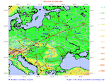
Comming back, I have not done a route but I am thinking the southern route looks best. Most of the ideas I've already mentioned but I will re-itterate them.
1. Never come out the same way you came in.
2. Crossing Middle Europe (Germany/France) would go right into the teeth of the fighting, heaviest concentration of VVS fighters.
3. Lower concentration of SU forces to the Southern Route (hopefully).
4. Possible to launch strong raid from Italy towards Eastern Europe to get SU attention, 15th Air Force Max Effort?
5. Potential for landing in the hands of friendly civilians greater in Poland than in Germany.
Would go from Moscow to Poland and on to Italy. Used Verona as the landing airfield (not sure this is accurate for 1945 as I went with present numbers, if another field is better, let me know)
Here are the numbers:
Route between UUDD (MOSKVA (MOSCOW), MOSKOVSKAYA OBLAST', RUSSIA) and LIPX (VERONA, VENETO, ITALIA (ITALY)):
Distance along great circle: 1362.7 statute miles, 1184.2 nautical miles, 2193.1 kilometers
Initial true great circle heading: 250.8 degrees (west-southwest)
Flight time at 220 knots: 5 hours 22 minutes
Attachments
Hi Delcyros,
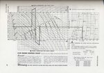
Here is the cruise control chart from the B-29 Airplane Commander Training Manual (AAF Manual No. 50-9).
It looks like Moscow is within easy reach for the B-29 - I figure the bomb bay tanks won't even be necessary, and the plane will climb quicker and cruise higher without.
The altitude limit of the chart (rather than the aircraft however shows that cruising at 30000 ft, though possible, is not usually expected from the B-29.
Regards,
Henning (HoHun)
Here is the cruise control chart from the B-29 Airplane Commander Training Manual (AAF Manual No. 50-9).
It looks like Moscow is within easy reach for the B-29 - I figure the bomb bay tanks won't even be necessary, and the plane will climb quicker and cruise higher without.
The altitude limit of the chart (rather than the aircraft
however shows that cruising at 30000 ft, though possible, is not usually expected from the B-29.Regards,
Henning (HoHun)
Attachments
Delc, read the chart. Yeah, that's what it says. True air speed and Indicated Air Speed are very different due to altitude and temperature. Maybe I spend to much time below 10k to notice it. Tell the truth, first time I've heard of it. Gotta get somebody like Flyboy J or Mkloby to eyeball. They have more stick time than I do.
As for working out the throttle settings for a B29 in that configuration (close to max weight), it will take somebody with a lot of knowledge on the engineer's station. I believe they had a lot to do with keeping the engines happy. Maybe Syscom again.
One thing that did pop into my head is the density altitude for England in August. If it is hot, muggy day, they are going to need every inch of runway to get up. Just another detail to think about. What is the density altitude of the home field at 2200 on the night of the mission? It could make the takeoff a bit wild for the pilot and crew (visions of Lindberg taking off for his transatlantic flight would look similar).
One last point. Both the airplane and the crew are going to be very important for the Soviets to get their hands on. Both would be best, but if it comes to a choice, they would probably prefer the crew. What they know about the mission (and the parameters of the bomb) would be more extensive than the aircraft itself.
Just a thought.
Njaco
The Pop-Tart Whisperer
Feel like I'm a sniper here...any thought to a Halpro / Ploesti type mission? Low on the deck, out of radar until near target. What would be the engine performance at a lower altitude? I'll go away now.
Feel like I'm a sniper here...any thought to a Halpro / Ploesti type mission? Low on the deck, out of radar until near target. What would be the engine performance at a lower altitude? I'll go away now.
Fear not comrade, their capitalist plot will come to nought, I have informed the Motherland and they are ready!
Feel like I'm a sniper here...any thought to a Halpro / Ploesti type mission? Low on the deck, out of radar until near target. What would be the engine performance at a lower altitude? I'll go away now.
On the way in, maybe. But it would be hairy. 1500 miles at tree top level. UGGGGHHHHH, that's gonna be a lot of work for the pilots. Plus, the sun will be up about half way through the mission. And the VVS is a low altitude air force. You'd be in their back yard, playing in their sandbox. Not good. All those Yaks and Laggs would be a real nusiance
Plus, you're fuel consumption is generally pretty high at low altitudes and relatively high speed. Can't do a 220 knot run down there. Have to be up as fast as it can go without blowing the engines up. On top of that, you'll have to climb (fast) to altitude of 25-30K to set up for the bomb run/bombing. Lower and you end up closer to the blast zone.
So, in short, you're climbing at 170 mph, within 200 miles of Moscow with fighters on you thicker than flies on a turd.
The only way I could think it would work is with a delayed detonation (parachutes and a drop at 10K or so) or with a smaller bomb, smaller (and faster) aircraft doing a pull up and bomb pitch from some miles out, pulling over the top and making a run for it back the way it came.
Fear not comrade, their capitalist plot will come to nought, I have informed the Motherland and they are ready!
No worries, we have a secret weapon. A vodka sniffing missle! 100% effective in Mother Russia.
- Thread starter
- #37
delcyros
Tech Sergeant
HoHun wrote:
Henning, Can You explain this to me? I have checked every detail of the map but there indeed is no part relative to range on this chart. All You can derive from it is specific fuel consumption at a given horsepower, load and altitude. So I assume, You made a flight chart in order to get Your figures? Please feel free to post them.
Timshatz wrote:
The runway is concrete and 9.000ft. long, so I think it should work under good conditions (head wind is necessary). But we have to figure out whether or not the B-29 has to engage a climb immediately after take off or not. Problems I see in the engine cooling. At Guam they flew at comparable loads and had to dive down the 500ft. cliff before establishing a level flight and climb state finally. Not sure about Tinian as this airfield had no such slope. Don´t now either if our starting airport has trees in vicinity or not but construcion works should be possible in the timeframe in question.
I am working on a wind condition but it is difficult to figure out which figures could be known to the USAAF meteorological service and what couldn´t. There were no meteostations in a radius of 800-1000mls around Moscow accessable to the USAAF weren´t?
It looks like Moscow is within easy reach for the B-29 - I figure the bomb bay tanks won't even be necessary, and the plane will climb quicker and cruise higher without.
Henning, Can You explain this to me? I have checked every detail of the map but there indeed is no part relative to range on this chart. All You can derive from it is specific fuel consumption at a given horsepower, load and altitude. So I assume, You made a flight chart in order to get Your figures? Please feel free to post them.
Timshatz wrote:
One thing that did pop into my head is the density altitude for England in August. If it is hot, muggy day, they are going to need every inch of runway to get up. Just another detail to think about. What is the density altitude of the home field at 2200 on the night of the mission? It could make the takeoff a bit wild for the pilot and crew (visions of Lindberg taking off for his transatlantic flight would look similar).
The runway is concrete and 9.000ft. long, so I think it should work under good conditions (head wind is necessary). But we have to figure out whether or not the B-29 has to engage a climb immediately after take off or not. Problems I see in the engine cooling. At Guam they flew at comparable loads and had to dive down the 500ft. cliff before establishing a level flight and climb state finally. Not sure about Tinian as this airfield had no such slope. Don´t now either if our starting airport has trees in vicinity or not but construcion works should be possible in the timeframe in question.
I am working on a wind condition but it is difficult to figure out which figures could be known to the USAAF meteorological service and what couldn´t. There were no meteostations in a radius of 800-1000mls around Moscow accessable to the USAAF weren´t?
Looking at the maps and aerial photos, trees and buildings shouldn't be a problem at any of the 3 emergency fields. Manston is at 170 feet, with slopes down from either end, and no trees near. Both Woodbridge and Carnaby are lower, at about 30 - 40 ft, Woodbridge has trees about 3,000 ft from either end of the runway.
Delc, have also read about loaded B29s taking off and flying in the ground effect. Some flew for a considerable distance in it. Not really an option in England.
However, having read HoHun's chart, it looks like there is only 4% more power required with a 5,000ft density altitude. That should be no problem.
The B29 has a helluva lot of power to it!
As for the weather en route, I would guess you would run out of timely info somewhere near Denmark. After that, it would be forecast weather.
I don't think the Soviets were big on giving out weather forecasts to anyone. Even their own citizens!
Hi Delcyros,
>Henning, Can You explain this to me? I have checked every detail of the map but there indeed is no part relative to range on this chart. All You can derive from it is specific fuel consumption at a given horsepower, load and altitude.
The horizontal axis for the central diagram is cruise speed, and we know the fuel capacity of the B-29, so we can derive range. (From the manual, I'd say your first post actually listed a B-29A, while I think we'd have a "plain" B-29 with a slightly larger centre tank. I might be wrong, though.)
What we don't know is the actual cowl flap position, but it seems the WW2 aircraft were fairly content with small openings at high altitudes due to the low air temperatures.
I have zig-zagged over the chart a couple of times, but only to figure out the general trend. It takes a lot of work to derive an accurate flight plan from that complex chart, so I'm afraid I can't offer anything definite.
Regards,
Henning (HoHun)
Users who are viewing this thread
Total: 1 (members: 0, guests: 1)