Forgotten battlefield

Ad: This forum contains affiliate links to products on Amazon and eBay. More information in Terms and rules

Marcel

rotartsinimdA
Staff
Admin
Mod
10,636
4,866
Sep 19, 2006
Dordrecht
www.redbeatband.nl
Last week I was on holiday in Gelderland and did some hiking. Suddenly I found myself at a little canal, which had an enormous dyke on one side (much to big for the little canal) and no dyke on the other side, which is weird. It turned out to be the notorious Grebbe linie dyke, the line where the Dutch hoped to stop the German advance in 1940. The place were I was was between Woudenberg and Scherpenzeel. The German Army did a major attack on the line there on May 13th 1940. Although vastly outnumbered (3.5 batallion in total against the whole 227th German division) and without aid of airforce or big artillery, the line held. The Germans stopped attacking when the Dutch surrendered after the bombing of Rotterdam. Today, we can only find a bunch of small bunkers on the dyke. Some people reconstructed a part of the trench on the dyke, so we can see what it looked like. futhermore they reconstructed a lookout post in a tree.

The photo's:
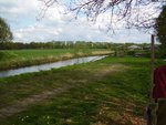
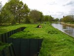
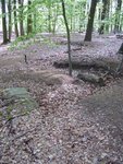
1. the dyke as it is now
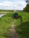
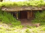
2. The trench
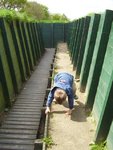
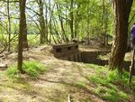
3. My son in the reconstructed trench
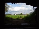
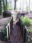
4. View on Scherpenzeel from a MG position
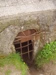
5. The MG position from outside
6. Looking towards the watertower of Woudenberg from where the Dutch saw the enemy coming
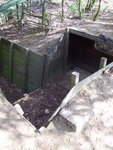
7. The little bunker (kazemat) took a direct hit on the gun position
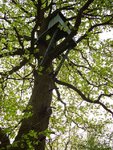
8. The lookout post in the tree
 

Attachments

  • P4300065.JPG
    P4300065.JPG
    77.4 KB · Views: 253
  • P4300066.JPG
    P4300066.JPG
    72.7 KB · Views: 275
  • P4300069.JPG
    P4300069.JPG
    74.4 KB · Views: 255
  • P4300071.JPG
    P4300071.JPG
    40.2 KB · Views: 240
  • P4300072.JPG
    P4300072.JPG
    77.4 KB · Views: 320
  • P4300083.JPG
    P4300083.JPG
    85.7 KB · Views: 253
  • P4300078.JPG
    P4300078.JPG
    73.8 KB · Views: 251
  • P4300073.JPG
    P4300073.JPG
    71.6 KB · Views: 250
A few kilometers to the south you'll find the Grebbeberg, which with the most southern point of the Grebbe linie. IMO one of the most beautiful places of the Netherlands. Nature and history comes together here. It's a 50 metres high wall created by a glacier in the ice age. On the edge you have a wide view over the flat Dutch countryside. One one side you'll find a prehistoric fortification. It's a place which I recommend you to go if you ever come to the Netherlands. It's something different then the same old Amsterdam and Kinderdijk again.
At the foot of the hill you find some 1760's fortifications. This was the place where the brunt of the battle was. 2 Battalions, about 2500 Dutch soldiers faced two divisions (about 20,000) of German soldiers and fought for 3 days. The Germans arrived here in the evening of may 10th. On May 13th they finally broke through. It was not a total victory, as the Dutch could mostly draw back on the second line, the Waterlinie. Not that it helped, the bombing of Rotterdam ended the fight. More then 400 of the defenders died here. The Dutch had a civilian army, so most of them were clerks, greengrocers, farmers etc. 700 of the Dutch soldiers dead are buried here. if you walk around and look good, you'll find traces of the battle. The most obvious being the little bunkers. But you can find trenches if you look hard.
Unfortunately, my pictures of the countryside didn't do it justice, so you should come and see for yourself. I have pictures however of some WW2 artefacts.
Photo's:
1. Again a small bunker, latest addition on the line in 1939. From here, an MG had to stop the Germans. Unfortunately, Government greediness prevented cutting down the apple trees in front, so they could only see for about 50 metres. Here you can see that the Dutch army was already defeated by their own government, before the Germans did.
2. Traces of a trench in the first line
3. An )again) reconstructed piece of trench. This is the "stoplijn", the last line of defence. Here died Dutch warhero Majoor Jacometti in a fruitless attempt to throw the Germans of the hill.
4. Shooting positions.
 

Attachments

  • P5020097.JPG
    P5020097.JPG
    86.2 KB · Views: 239
  • P5020096.JPG
    P5020096.JPG
    74.2 KB · Views: 252
  • P5020094.JPG
    P5020094.JPG
    81.1 KB · Views: 251
  • P5020095.JPG
    P5020095.JPG
    75 KB · Views: 264
Great shots Marcel.

Can understand how they stopped them with those fields of fire. Even the Wermacht would have problems covering that ground, wide open. Looks to be about 400 yds to the town from that machine gun post. Flat as a billard table too.

What is the ground like on the other side of the canal? Is it polder (sp?)? Would it support armor? If the German's tanks got bogged down out there then it was left to the infantry to get across the canal. Then, you're back to WW1.

No, it's not polder. It's sandy ground.The Dutch thought it wouldn't, but the Germans proved it did support ground. At that time, some of the field was under water, but again, Dutch greedyness got in the way and they started to flood the country too late. Germans mainly used artillery to shoot their way through at this place. As the Dutch hardly had any artillery, they could safely do so. The brake through at the Grebbeberg made it low priority on May 13th, so I guess that fortunately for the Dutch soldiers, they never really did the great push here.
 

Users who are viewing this thread

Back