Navigation
Install the app
How to install the app on iOS
Follow along with the video below to see how to install our site as a web app on your home screen.
Note: This feature may not be available in some browsers.
More options
You are using an out of date browser. It may not display this or other websites correctly.
You should upgrade or use an alternative browser.
You should upgrade or use an alternative browser.
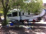
Camping on the Arkansas river
Ad: This forum contains affiliate links to products on Amazon and eBay. More information in Terms and rules
More options
Who Replied?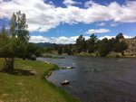
mikewint
Captain
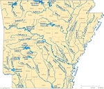
Torch, where did you camp? We're in Lakeview, AR right on Bull Shoals Lake which is the last impound lake of the White River
Yeah this looks horrible. You must have hated it. 
vikingBerserker
Lieutenant General
Poor guy, be strong!!
Thorlifter
Captain
Hang in there Torch. Soon you will be back in the inner city with sounds of cops, fire trucks, gun shots, and getting mugged. Why are you torturing yourself by that clean river and clear skies?
Wildcat
Major
Nice!
how could you allow yourself to be seduced to the dark side....
Friggin' looks awesome though!
Friggin' looks awesome though!
- Thread starter
- #8
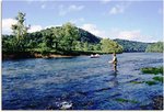
Lol,I used to love blue water fishing,never fished in Colorado since I moved there in 95. That week I caught my first Brown trout,think I'm hooked again.. This was right between Salida and Canon City on rt 50. Very spotty WiFi so no "work", read alot, fished, hiked. I had forgotten what relaxing meant.
JEALOUS!
at6
1st Sergeant
Where's my fishing pole?
mikewint
Captain
at6
1st Sergeant
All of the best rivers are in the Rockies and the west coast as in the Sierra Nevada range.
mikewint
Captain
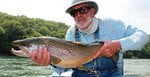
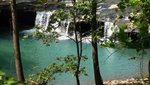
Them's fighten words pardner! The White has been tamed by dams, hydroelectric and other, but it is still very scenic and the cold 40F to 48F water coming out of the dam has turned the White into a cold water river with some fantastic trout fishing (Brown Rainbow usually).
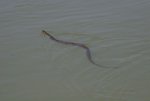
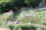
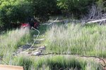
Besides the frigid water there are other reason not to swim in the river
Besides the frigid water there are other reason not to swim in the river
Attachments
Well that looks just hellish... ")
- Thread starter
- #15
mikewint
Captain
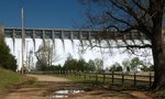
Torch, that's Green's Ferry, you can see it on my map south of Bull Shoals and Lake Norfork. I think the area is beautiful. The Corps of engineers owns all of the lake shore up to 700ft MSL so NO commercial development. One can see bottom 25 to 30ft down. The Lake is 85mi long and goes up into Missouri. The White drains 14,000 sq miles. Now being a flood control, reservoir, and the last lake in a chain of 4 on the White water levels are HIGHLY variable. Normal pool is 654ft MSL. On Apr 24 it was 668; on May 9 664; and now June 10 it is 678 ft MSL. Boat docks must therefore float and be moved in or out as levels change a really fun procedure. In 2011 the Lake reached over 696ft MSL and the Tainter Gates were opened to relieve pressure on the dam
Attachments
- Thread starter
- #17
mikewint
Captain
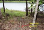
Nope, it would be nice but then raising/lowering the Lake level would harm private property. Therefore the Army Corps of Engineers retained ownership of all land to a height of 700ft MSL (Top of Dam) we are 120ft further up the ridge on just 3 acres
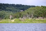
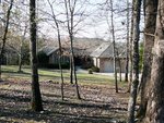
From the cove
From the front
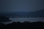
Dam at night from back deck
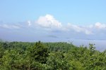
Lake in the AM, the big hill (in Colorado terminology) to the left with the towers is Bull Mountain (Arkansas terminology)
From the cove
From the front
Dam at night from back deck
Lake in the AM, the big hill (in Colorado terminology) to the left with the towers is Bull Mountain (Arkansas terminology)
Attachments
Last edited:
- Thread starter
- #19
mikewint
Captain
Thanks, I love it here. Don't have your mountains but the Lake is beautiful and never freezes
Users who are viewing this thread
Total: 1 (members: 0, guests: 1)