syscom3
Pacific Historian
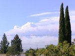
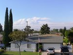
I thought some of you would like to see this link that gives a good overview of the fire that's burning in the mountains above Los Angeles.
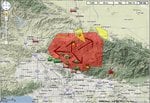
InciWeb the Incident Information System: Station Fire
Station IC - Google Maps
What makes this fire so unusual is the complete lack of wind. The smoke is not blowing horizontally, but straight up.
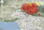
InciWeb the Incident Information System: Station Fire
Station IC - Google Maps
What makes this fire so unusual is the complete lack of wind. The smoke is not blowing horizontally, but straight up.