Nuuumannn's European Tour of 2019

Ad: This forum contains affiliate links to products on Amazon and eBay. More information in Terms and rules

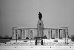
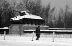
I can fully understand that Grant.
I felt the same, when describing the visits I made to former airfield sites (mainly WW2 USAAF) in Norfolk and Suffolk recently, shown in my "The Travels of Tel's Tin Tent" thread. A good sense of satisfaction, being able to share the views and 'atmosphere' with the members here, particularly our American friends, who may have had relatives based on the places visited.
 
Re: #29; Great pictures.

In 1962/1963 there were Soviet guards walking their posts at the Soviet War Memorial but there were British soldiers walking back and forth in front of the Memorial, protecting the Soviet soldiers.
 

Attachments

  • Soviet War Memorial W. Berlin 4 B&W.jpg
    Soviet War Memorial W. Berlin 4 B&W.jpg
    323.6 KB · Views: 37
  • Soviet War Memorial W. Berlin 8 B&W British Soldier.jpg
    Soviet War Memorial W. Berlin 8 B&W British Soldier.jpg
    348.7 KB · Views: 31
Thanks again, guys. Busy at home with kiddies and stuff, although I'd much rather be reliving my trip with you guys, to be frank!

So, we are now in front of the Reichstag, looking over the Platz Der Republik, what was originally called the Konigsplatz (King's Place). In April 1945, when the Soviets made their final assault on the Reichstag, they came from the left of this picture because right in front was a trench that had been dug for the U-bahn that was to connect the proposed Volkshalle to the network. It was initially assumed that it was a defensive trench, having filled with water, but its purpose was more prosaic. This was the original location of the Siegessaule and the Bismarck and Moltkedenkmalen, which sat among a sculpted garden and was intersected by a north-south avenue named the Siegesallee, or Victory Alley, which was lined by 32 marble statues of Prussian heroes. Originally created in 1735, the Konigsplatz saw the Siegessaule installed first, in 1873, with a palace belonging to a Polish count occupying where the Reichstag now stands. Work was begun on the building in 1884, taking ten years to build. The square gained the name Platz Der Republik during the Weimar Republic days after the end of the Great War, although the Nazis named it as it previously had been, owing to their disdain for the former regime.

View attachment 545886Berlin Tour 23

How the Konigsplatz looked on completion of the Reichstag. Note that the Siegesaulle is modelled at its original height before Speer insisted it become larger after it was moved, with three fluted columns above the granite rotunda. The Bismarckdenkmal can be seen adjacent to the Reichstag-Gebaude (Hall of the Imperial Diet), as the building was officially known, with the Moltkedenkmal located this side of the Siegesaulle, out of the picture.

View attachment 545887Berlin Tour 24

Back to April 1945 and it wasn't until 6pm on 30 April that the final assault on the Reichstag by the Soviets began. This was after the Krolloper building, across the Konigsplatz from the Reichstag had been assaulted, which led to high losses among the Russians. After dark, with the support of Soviet self-propelled artillery, while still under fire from the Zoo bunker's guns 2 kilometres away, Soviet troops of the 150th Division breached the outer doors, firing a mortar horizontally at them and busting their way in. Their entry into the building was met with fierce resistance and hand to hand combat broke out with the SS troops determined to hold out. Whilst the fighting indoors continued, the 171st Division secured the exterior and the trappings highlighting the Soviet victory, the ceremonial banners prepared especially for the occasion were brought into the building. With 70 minutes to go before the deadline of the 1st of May arrived, the Red Banner was finally hoisted above the ramparts on the eastern side of the building. Some 2,200 Soviets and 2,500 German soldiers had lost their lives in the assault on Berlin's soul. Meanwhile, the battle for the rest of the city continued. Today, the Reichstag serves at the German parliament again, with reconstruction undertaken in the late 1990s. Although not visible in this picture, there are always queues of people, as it is open to the public, but a visit has to be booked in advance, otherwise, you are queueing for ages.

View attachment 545888Berlin Tour 25

A monument to 96 parliamentary citizens of the Weimar Republic murdered by the Nazis, located outside the entry gates to the Reichstag. One of the many memorials to the scars in the tissue of this city's history left by the Nazis, and we'll be visiting some of them along the way.

View attachment 545889Berlin Tour 26

This is the first Soviet war memorial erected in Berlin after the war's end. There is another, which we will see later on in the tour, but this one holds a very prominent position in the Tiergarten on Strasse des 17 Juni, or Charlottenburger Chausee as it was then. Built in 1945 on the site of the graves of those 2,200 Soviet soldiers who lost their lives capturing the Reichstag, the Soviets worked day and night to get it completed by 11 November as a permanent reminder of their sacrifice. It was made, in a typical act of Soviet retribution, from stone dragged from the ruins of Hitler's Reichs Chancellery on Voss Strasse and by placing it astride the former Siegessallee within sight of the Reichstag, although the parliament building is today obscured from view of the monument by the regenerating foliage that was so noticeably absent in 1945. The guns are ML-20 152mm howitzers. American journalist William Shirer, who had covered the rise of the Nazis from Berlin until 1940, returned in 1945 and was present at the unveilling of the memorial, wrote that when, 'the Russians unveiled the mammoth monument, you could almost hear Hitler's Bolshevik-hating bones rattling in their grave."

View attachment 545890Berlin Tour 27

Where would the Soviet Army be without the T-34? It's only natural that this tangible symbol of their victory, placed on so many memorial plinths from Berlin east to Moscow, should be present at the place of their objective during their hardest struggle. There are two of these flanking the memorial at street level.

View attachment 545891Berlin Tour 28

The Soviet War Memorial from the road, with the T-34s just outside the picture. This is a functioning memorial today, where commemorations are still held in honour of the fallen. During the Cold War, the memorial was in the British sector and after its construction was placed under 24 hour guard by Soviet soldiers. Intriguingly, this continued, with permission of the Allied Control Commission until 1991, owing to the fact that it is the site of war graves. This view is as close as the public could get to the monument, the armed Soviet guards ensuring that there was no access to it, until the fall of the Soviet Union, when it became just another monument ot the city's colourful past that the public and tourists could marvel at.

View attachment 545892Berlin Tour 29

The Strasse Des 17 Juni looking west toward the Siegesaulle, exactly one Roman Mile from this spot, as Albert Speer had intended. Lining this boulevard following its reconstruction were street lamps designed by Speer, which have all been removed, although there are some surviving in remote locations. The best place to see the Speer lamps is on the Frankfurter Allee, which we'll visit on another day. It's peculiar that the East German communists chose these reminders of Speer's influence on the city to line their most prominent avenue.

View attachment 545893Berlin Tour 30

Go East, Young Man... The Brandenburg Gate at the entrance to Pariser Platz and Unter Den Linden. Three things of immediate note in this picture, the tour busses, roving round Berlin in their hundreds at this time of year, the ever present TV Tower and the small statue in the centre of the island. This is called Der Rufer, the Caller or the Crier and is deliberatly placed facing what used to be East Berlin. Designed by Gerhard Marcks and initially cast in 1966, a copy was erected here a few months before the fall of the Wall in 1989. The statue is intended as a call for peace, but Marcks has also erected versions of Der Rufer in a few other cities round the world; that erected in Perth, Western Australia comemmorates victims of torture.

View attachment 545894Berlin Tour 31

The Brandenburg Gate, or Brandenburger Tor, that most well known and prominent of Berlin's public monuments was originally constructed between 1788 and 1791. back in the 17th Century, Berlin was a walled city of little note, with 18 roads that led to different locations within the principalities that were to eventually make up the Greater German Reich. At each of those roads from the city were gates and this one led to the principality of Brandenburg, hence its name. Atop the gate can be seen the Quadriga, which the French claim was theirs, although it wasn't, as we'll see in the next instalment of images. This is a reproduction since the original was mangled in the battle for the city in 1945. Initially as built, only the Royal Family could pass through the centre pillars, but now they let any old tourist from far flung parts of the world through them. Following WW2, the gate had suffered considerable damage and in a bizarre act of reconciliation, both the communist East Berlin and West Berlin governments agreed to jointly fund its reconstruction. If we were standing here from 1961, we would be facing the Wall as it ran directly in front of the gate. This meant that from the eastern side, the public were not allowed near it. From this side however, the wall became a target for grafitti and youngsters hurling things over it, to the consternation of the East German border guards!

View attachment 545895Berlin Tour 32

More from Berlin in the following days, when we head east and go to the heart of the Third Reich.

Here is the Brandenburg Gate, February 1963 looking into the Soviet Zone. Nobody walking through back then!
 

Attachments

  • Brandenburg Gate B&W.jpg
    Brandenburg Gate B&W.jpg
    391.9 KB · Views: 27
Thanks for following along.

From Hanna-Arentstrasse, we walk south on to the narrow Gertrude-Colmarstrasse that runs parallel with Wilhelmstrasse, to this rather innocent looking car park. It is hard to find a more incongruous place for the most notorious megalomaniac in human history to have met his death, but 30 feet below this dusty space are the remains of Hitler's bunker. We are facing south-east, with Wilhelmstrasse running to our left. In 1936, on this spot was located a hall named the Diplomatensaal that was connected to the rear of the old Chancellery on Wilhelmstrasse and below it the first air raid shelter suitable for the Fuhrer was constructed. This was later to be called the Vorbunker once the Fuhrerbunker proper had been constructed in 1944. When Speer ordered the construction of the new Reichs Chancellery on Vossstrasse in 1938, a series of interconnecting tunnels between the new building, the Vorbunker and ministries on Wilhelmstrasse, such as the Propaganda Ministry and the Foreign Ministry were built, but these had proven to be vulnerable to air raid damage during Allied raids in 1943, so a new shelter was planned, to be bigger than the existing one, the Vorbunker and deeper, too. Located 30 feet below the ground, with a roof comprising a concrete slab 2.8 metres thick, the new Fuhrerbunker was not yet complete in its entirety by May 1945 when the Fuhrer took his own life on a sofa in his office in the bunker, next to his wife, Eva Braun, who did the same.

This page gives a very good description of the bunker's layout, accompanied by illustrations: Führerbunker - Wikipedia

View attachment 546777Berlin Tour 43

From this view, we are looking north toward the location of the Fuhrerbunker and if we were here in 1945, this entire area was a building site while the finishing touches were being made to the complex. This was the Chancellery garden, with Vossstrasse and the Reichs Chancellery behind us and Wilhelmstrasse to our right. During DDR times, this entire area was empty, forming part of the Death Strip once the Wall was built. Following WW2's end, the Soviets, having taken everything from within the bunker complex, as well as from the chancellery and squirrelled it all back to Moscow, their attempts at destroying the steel reinforced concrete complex in 1947 was futile and the bunkers resisted destruction, so they flooded the entire complex and and covered the remains with dirt.

In the late 1980s however, the vacant land that bordered Wilhelmstrasse was earmarked for the building of swanky new apartment blocks, which the massive concrete fortfications below ground hindered the construction of, so further efforts were made to destroy the bunkers. Again, this proved too large an undertaking for the DDR workers and the apartments, seen in the background of the photo above went around the bunkers, but it also gave those who were curious and had a lot of nerve, since this was in the Death Zone next to the Wall, the opportunity to enter the bunker complex. Two years later, with German reunification and a total reconstruction of the entire block, work was undertaken to clear the place of unexploded ordnance, of which the city authorities are still discovering to this day - during my visit there was a UXB found at a building site not far from the city centre. This work, more extensive than that carried out by the East Germans, went further to destroy the bunker, owing to the desire to lower the ground level, after the Soviets had just piled dirt on top of the site. After an extensive survey of the bunker, which included brave souls entering the complex with cameras and clip-boards, the lot above floor level was demolished, with the concrete pad on which the bunker sat being buried again, this time, for the last time. Note the groups of people - these are official walking tours, congregating at the site and telling their version of the story. Incidentally, Hitler's lifeless body, his wife's and those of Goebbels and his wife and children were placed in a drainage trench and set alight, about where the clump of people to the left of the picture are.

View attachment 546778Berlin Tour 44

In this image, we are looking south along Wilhelmstrasse at the apartment complex that was constructed in 1988 around the bunker. Prior to the site's destruction during the war, we would be looking at the old Chancellery at Wilhelmstrasse Nr 77. Formerly Palais Schulenburg, Bismarck, the new Chanceller of the Greater German Reich from 1870, had the building enlarged for its governmental purpose and after the Great War, a new administrative wing was added at Wilhelmstrasse Nr 73, stretching to the corner of Vossstrasse. It was in this section that Chancellor Paul von Hindenburg had his offices, which then became Hitler's on his 'election' to the role in 1933. It was in front of an office on the first floor, not actually Hitler's as is often misconstrued, owing to the fact that the rooms facing the street got too hot in the summer, that Speer, newly appointed to the role of Inspector of Buildings in 1937, added a balcony for the Fuhrer to greet crowds of adoring fans who gathered outside. Never liking the building, Hitler said of it that it was only 'fit for a soap company' and that from the outside it gave the impression of 'a warehouse or of the city fire brigade building', while the inside was akin to 'a TB sanatorium'.

View attachment 546779Berlin Tour 45

We are now standing in a side street off Wilhelmstrasse on the opposite side of the road from where the old Reichs Chancellery stood. This is the Bundesministerium für Arbeit und Soziales, or the Ministry of Labour and Social Affairs. It occupies a building that the Nazis conveniently left behind for future use; the Reichsministerium für Volksaufklärung und Propaganda, RMVP or Propagandaministerium, the Reichs Ministry for Enlightenment and Propaganda. Within these walls, propaganda minister Josef Goebbels masterminded the Third Reich's image through censorship and governmental control over news media, the arts, and public broadcasting to become one of the most effective marketing tools of all 20th century dictatorships. Central to this ministry's role was the rise of the cult of personality, which promoted Hitler as being little less than a demi-god, as most ruthless dictators favour, and for a time, quite shockingly in retrospect, it worked - that is, until the inevitable world war, when Goebbels' words began to ring rather hollow.

View attachment 546780Berlin Tour 46

Back on Wilhelmstrasse, we have crossed the road and are standing in front of the block of flats we saw in the previous image looking down the street. This is the approximate location of the main public entrance to the new chancellery, the Reichskanzlei designed by Speer. Looking west, we would have been facing the courtyard that was known as the Ehrenhof, where vehicles would pull up to a tall double doorway guarded by two members of the Leibstandarte Adolf Hitler SS Division and flanked by four columns with a Reichsadler above it and sculptures by Arno Brecker of classical male figures depicting Die Partei, and Der Wehrmacht. And if this wasn't intimidating enough, through the 17 foot high doors, up some stairs into the entrance foyer, one walks into the 150 foot long Mosaiksaal, which was predominantly burgundy marble with a sky lit ceiling. After carefully navigating one's way across the slippery floor, the visitor reached the Rundersaal, which was a circular dome capped room that was designed to off-set a kink in the building, the entry door being slightly off-centre at its opposite end. This was the entrance into the main building proper, and the grand passage known as the Marmorgalerie - Speer's attempt to upstage the Hall of Mirrors at Versailles. All of this grandiosity gave an impression of might and power. When Speer questioned the bare marble floors that Hitler insisted that he not cover with rugs, as was his original intent, Hitler quipped, 'diplomats should have practise moving on a slippery surface!' How funny that this expression of grandeur has been replaced by Chinese and Mexican eateries!

View attachment 546781Berlin Tour 47

We are on the corner of Wilhelmstrasse and Vossstrasse looking west toward Potsdamer Platz, across at the location of the new Reichs Chancellery; the officious beating heart of German national socialism. At the end of January 1938, the busy Inspector of Buildings was given the instruction by the Fuhrer to construct a new Reichskanzlei to be completed in January 1939; a seemingly impossible task, one that Speer amazingly managed to pull off. Beginning with the air raid shelter work detailed in the previous posts, Speer later commented that he already knew how he wanted the building to look from the inside and worked his way around the existing space the length of Vossstrasse, which the building occupied. Work progressed around the clock, with some 4,500 people beavering away at it on two shifts. After the first ceremonial topping out on 1 August 1938, the building was completed 48 hours ahead of schedule on 7 January 1939. A truly extraordinary effort given the scale of what was achieved; a 1,400 foot long monstrosity that Hitler himself was extremely impressed with, giving great delight in showing people round his new realm.

View attachment 546782Berlin Tour 48

We are standing on Vossstrasse's north side facing due north, approximately where the Marmorgalerie stood in the new Reichskanzlei. This enormous length of Nazi grandiosity was 146 metres long at a breadth of 12 metres, at a height of 45 metres. anchored by another slippery marble floor, the side facing the road comprised 19 high windows constructed of burgundy marble known as Deutschesrot. Opposite stood five evenly spaced similarly framed doors, the centre one of which, crowned with a heraldic shield with the initials 'AH' was the entrance to Hitler's office, protected by two more of his personal SS bodyguards. On the top floor above the grand structure was his private apartment. Speer said of the Marmorgalerie that, 'Hitler was particularly impressed by my gallery because it was twice as long as the Hall of Mirrors at Versailles'. The ignominy, that this most impressive architectural symbol of the Third Reich should end up as a non-descript car park.

View attachment 546783Berlin Tour 49

From the Marmorgalerie we move through Hitler's office, into the walled Chancellery garden, through which the Fuhrer would sneak out at night to visit his friend, the architect. The underground bunkers were out of the picture to the right. Speer's description of Hitler's arbeitsplatz describes it better than I could:

"The Fuhrer's office looks out to the garden terrace through five French windows 6 metres high and two metres wide. Five similar bays to those formed by the French widdows are repeated on the opposite wall, constructed with fine inlaid panels. In the middle bay on this side is the entrance door leading in from the Marmorgalerie. The office, which is 27 metrers long and 14.5 metres wide, has walls consisting of a dark red marble from Austria known as Limbacher. With a height of 9.75 metres, the room has a panelled ceiling with beams of darker wood that is a splendid feat of joinery. On the floor made of Ruhpolding marble lies a single large carpet." "His study met with his undivided approval. He was particularly pleased by the inlay on his desk representing a sword half drawn from its sheath. 'Good, good. When the diplomats sitting in front of me at this desk see that, they'll learn to shiver and shake'".

This building is the Landesvertretung Saarland, the government department representing the state of Saarland in western Germany.

View attachment 546784Berlin Tour 50

Doubling back eastwards along Vossstrasse, we have entered the underground at the Mohrenstrasse U-bahn station. Why? Because it is rumoured that the walls and columns lining the platform were constructed of burgundy marble scavenged from the ruins of the Reichskanzlei. It has been proposed, according to 'new research', that this might not be the case, but I question this, especially since the station was reconstructed by the Soviets/East Germans, who repurposed as much as they could possibly do so from the chancellery ruins - and where else in the rubble of post-war Berlin could you find rich burgundy marble, except the aforementioned spaces? Besides, the same material was used to clad the massive stone columns resembling draped Soviet Red Banners at the second Soviet war memorial at Treptower Park, in the south east of the city (which we'll visit over the coming days), which was done, of course in retribution, as was the first Soviet war memorial on the Tiergarten. I'm sticking with the Reichskanzlei marble theory, especially since Mohrenstrasse U-bahn is literally a marble stone's throw from Vossstrasse; not far at all to drag reconstituted building materiels.

View attachment 546785Berlin Tour 51

Our next stop is south along Wilhelmstrasse to the corner of Leipzigerstrasse, and the Platz des Volksaufstandes von 1953. This a memorial corner inlaid into the existing building commemorating the 17 June uprising in East Berlin in 1953, the reason that Strasse des 17 Juni was named. Inside the columned walkway to the left of the picture is a mural by Max Lingner depicting Socialist style scenes of harmony and prosperity, which overlooks the memorial, almost as an affront to the regime responsible for the turmoil caused on that day. Not surprisingly, the East German government would never have allowed such a commemoration, let alone on the grounds of the very building in which the state of the DDR was pronounced on 7 October 1949. Today this building is known as Detlev-Rohwedder Haus, named after politician Detlev Karsten Rohwedder, a Social-Democratic Party member who was tragically assassinated in his home in Dusseldorf on 1 April 1991. It serves as the Bundesministerium der Finanzen, or Federal Ministry of Finance today, but its original purpose was abbreviated into three incongruous letters, of which we on this forum are very familiar. RLM.

View attachment 546786Berlin Tour 52

Next, more Nazi naughtiness; the RLM building and the horrors of Prinz Albrechtstrasse.

Here are a few more 1962/1963 photos that add to the perspective of your excellent photos of Berlin 2019. The Cold War is largely forgotten- no one makes "Cold War Veteran" bumper stickers, hats or T-shirts. Only those of us who were there and saw the Soviets & East Germans up close know what it was like.
 

Attachments

  • img206.jpg
    img206.jpg
    252 KB · Views: 33
  • img198.jpg
    img198.jpg
    301.8 KB · Views: 46
  • img201.jpg
    img201.jpg
    185.5 KB · Views: 38
  • Potsdammerplatz 1962.jpg
    Potsdammerplatz 1962.jpg
    217.8 KB · Views: 34
  • British Checkpoint 2 B&W.jpg
    British Checkpoint 2 B&W.jpg
    349.4 KB · Views: 40
  • Checkpoint Charlie B&W.jpg
    Checkpoint Charlie B&W.jpg
    427.6 KB · Views: 36
  • Grenz Poleizi B&W.jpg
    Grenz Poleizi B&W.jpg
    446.8 KB · Views: 35
  • Guard Tower B&W.jpg
    Guard Tower B&W.jpg
    616.9 KB · Views: 34
  • Soviet Guard Tower on Autobahn 2 B&W.jpg
    Soviet Guard Tower on Autobahn 2 B&W.jpg
    533.7 KB · Views: 36
Here are a few more 1962/1963 photos that add to the perspective of your excellent photos of Berlin 2019.

Thanks for sharing those, Manta, I love looking at old photos of Berlin at that time. I spent a lot of time in the city post Cold War, having dated a Berlin lass, whom I stayed with and who accompanied me on my jaunts round the city. Like with my Great War battlefield trip, it's difficult to put it into perspective visually because so much has changed. Nonetheless, it's fun going to these places and imagining.

Only those of us who were there and saw the Soviets & East Germans up close know what it was like.

And that's what brings it to life. I've talked to people on both sides, East and West, about life in Berlin and it was a unique situation. Again, thanks for sharing. Keep posting your photos Manta and feel free to share your experiences. I for one would like to read about them.
 
Thanks for sharing those, Manta, I love looking at old photos of Berlin at that time. I spent a lot of time in the city post Cold War, having dated a Berlin lass, whom I stayed with and who accompanied me on my jaunts round the city. Like with my Great War battlefield trip, it's difficult to put it into perspective visually because so much has changed. Nonetheless, it's fun going to these places and imagining.


And that's what brings it to life. I've talked to people on both sides, East and West, about life in Berlin and it was a unique situation. Again, thanks for sharing. Keep posting your photos Manta and feel free to share your experiences. I for one would like to read about them.

OK, one more story about Cold War Berlin-

In 1963 I was in Berlin on leave from my Corporal missile unit in Babenhausen. I had been driving around various places taking pictures of the wall, East German guards, guard towers, patrol boats, etc. when I met a young German man with a bandaged arm in a sling and woman there on the west side of the wall. We struck up a conversation (she spoke English) and I found out that her companion had been released from the hospital that morning and he had returned to the place where he had crashed a Soviet 9-ton armored car into the wall to try to escape from East Germany. The armored car did not crash all the way through the wall, so he had climbed up on its hood and was crawling through the barbed wire on top of the wall when he was shot twice. Some West Germans had heard the shooting and had climbed up and pulled him over to safety. They carried the unconscious young man to a nearby gasthouse and laid him on a table until an ambulance arrived. He awoke, looked around where he was lying, saw the labels on all the liquor bottles and then knew he had escaped to the West.

In 1993 I found a box of photos that I had taken in Berlin many years ago and saw this photo of the young Germans and I realized that it was almost exactly 50 years ago that I had taken that picture. I never knew their names but I thought that such a spectacular escape must have made the news, I searched the internet and found that story. The young man's name was Wolfgang Engels and a racing buddy in Germany found his e-mail address. I sent him a message explaining who I was and about meeting him that morning at the wall. I attached the picture of him and one of me at that time (my avatar) and sent it; I received a very nice e-mail reply from Wolfgang which ended with his explaining that he and his wife, Doris, were planning a small celebration of the 50th anniversary of his escape and inviting me and my wife to come to Germany and to attend their celebration. We had talked about someday going back to Germany to visit and this was a good reason to do it.

Joline and I flew to Berlin in April 2013 and traveled through Germany, seeing some old familiar places, including my old missile unit kaserne, now closed and guarded by a lone former East German officer. We met Wolfgang and Doris at their home and had a very nice time, also meeting some of his friends. Wolfgang related quite a bit of detail about his life and of his escape. The story can be read here:

'I'm leaving for the West, who's coming?'

I think there is a video on YouTube as well. Well,nuuuumannn, that's just another little story to put Berlin in context.

Regards, Neil Albaugh ex- SP5 US Army 1960-1963
 

Attachments

  • Wolfgang Engels 1.jpg
    Wolfgang Engels 1.jpg
    36.2 KB · Views: 31
Thank you Marcel. I'll be posting more pics that we took the night you came to visit as well.

So, back from an exciting diversion to Berlin, to Vlanderen in 1917 and an almighty kerfuffle. At 3:10 am on the morning of 7 June 1917, British and Australian laid mines blew up underneath the German trenches that created the loudest man made noise up to that point in history, louder even than that which created the Lochnagar crater we saw in the Somme region, owing to their being 19 bangs at around the same time! The noise, it was said, could be heard in London - British Prime Minister David Lloyd-George said he had heard and felt it. The explosions were responsible for wiping out some 10,000 German soldiers in their trenches; those that survived the initial concussion were thrust backwards with a savage artillery and gas barrage and the advance of some nine divisions across the front that stretched from Hooge to the east of Ieper to south of the town of Mesen. Of 22 mines, only 19 exploded. One was discovered by the Germans and blocked and one went off in 1955 owing to a lightning strike, which means somewhere below the peaceful Vlanderen countryside is one more lot of explosives, the exact whereabouts of which have been lost in time, awaiting their moment...

This is the Spanbroekmolen crater, which had a delayed explosion and has become subject to a long standing story that the 36th Ulster Division, them from the Somme battles at the Ancre River, advanced on the German trench just as the mine exploded, thus suffering high losses, although this might just be one of those myths that have circulated since. Started by the 171st Tunnelling Company of the Royal Engineers on 1 January 1916 and completed by 1 July that year, it wasn't until nearly a year later that explosives were laid as German tunnelling had destroyed one of the galleries in March 1917, which required fresh tunnelling to be completed in support of the offensive, whose planning had begun in early 1916. The bang was caused by 500 lbs each of ammonal and dynamite.

Subsequently, the crater, the biggest of all the British mines blown on 7 June, quickly filled with water and after the war was used by local children as a swimming hole. It was Charles Wakefield, the oil magnate of Castrol Oil and future mayor of London who became aware that the big hole being neglected in Vlanderen was a war grave and had his other project in the region, Talbot House, a convalescing hotel for soldiers during the war in the town of Poperinge, which we'll visit, purchase the land and turn it into a memorial. It was named The Pool of Peace. Incidentally, Wakefield was a philanthropist and through his supply of oil to the aviation industry he came in contact with many famous aviators of the time, including record breaking New Zealand aviatrix Jean Batten, with whom it is rumoured he had an affair.

48818048883_79decebd92_b.jpg
Great War Tour 90

Now we head toward the town of Mesen and the Ridge the fuss was all about. These are more Remembrance Elms; we are on the German lines looking toward the British - note their close proximity. The Messines Ridge Offensive's aim was to breach the German lines and close down the German held southern and eastern flanks of the Ypres salient. Held by the British, because the Germans occupied the territory around the salient, the town of Ypres and Commonwealth forces therein were suffering under the weight of constant artillery attacks and an offensive to counter the Germans was planned by Gen Herbert Plumer of the British 2nd Division. It was a tactical success for the British and put her forces in a more secure position for the forthcoming Third Battle of Ypres, scheduled to begin a few months after the Messines offensive.

48818048678_19bcc80f46_b.jpg
Great War Tour 91

We now rejoin the New Zealanders, whom had moved northwards since their success during Flers-Courcellette - which see. For the Messines Ridge battle, the Kiwis were based in the region between the village of Wulvergem, which we saw in the last instalment and Ploogsteert Wood, better known as Plug Street Wood, obviously, in the valley of the Douvre River. Congregating in the many farm steadings in the local area, this is Ration farm, where the New Zealand officers were housed and from this view we can see Hill 63 in the background; the north-western corner of Plug Street Wood. Hill 63 and Kemmelsberg were of vital importance to the British throughout the war as communications to and from the Channel ports where British soldiers and supplies arrived in mainland Europe were conducted from these points. As we found out earlier, the British would lose Kemmelsberg to the Germans during the Kaiserschlact, or the Spring Offensive in April 1918 and would not regain it until September, during the 100 Days Offensive, where all the gains the Germans made in Spring were lost.

48818048528_0d0d3019d7_b.jpg
Great War Tour 92

Ration Farm steadings, beautifully restored, where the officers were billetted; the NZ Div having been in the region for three months prior to the engagement, with their HQ at Steenwerck. This is also the location of the Le Plus Douvre (Ration Farm) CWGC Cemetery, within which are 349 graves, 61 of them new Zealanders. Ration farm was named as such because vehicles carrying rations were brought here within the dead of night for distribution around the lines.

48818562652_f489edde53_b.jpg
Great War Tour 93

We then head back onto the main road between Wulvergem and Mesen to the Messines Ridge Memorial CWGC Cemetery and its Cross of Sacrifice. There are 579 graves here, including 297 UK, 204 Australians, 67 New Zealanders, ten South Africans and one Canadian.

48818047913_129eef983a_b.jpg
Great War Tour 94

In this cemetery is also the Messines Ridge New Zealand Memorial to over 800 New Zealand soldiers with no known grave.

48818407691_e2ed1108ed_b.jpg
Great War Tour 95

The ring of New Zealanders' names and their units below the Cross of Sacrifice.

48818407231_de5c5f0303_b.jpg
Great War Tour 96

On the way I spotted this unexploded shell sitting outside a barn; an example of what locals call The Iron Harvest. All over this region, farmers are still recovering items from the battlefields and are advised by the Belgian authorities to leave them outside their properties for collection by the Belgian bomb disposal unit, DOVO, of the Belgian Army. Each item is assessed to determine its calibre and nature of the explosive within the casing, then is photographed and catalogued before being destroyed.

48818561472_50f60516a9_b.jpg
Great War Tour 97

After our quick detour to the cemetery, we are now facing the infamous Messines Ridge, looking directly at the German Uhlan trench, which is now occupied by the New Zealand Memorial obelisk. Beyond the ridge is the town of Mesen. On the morning of 7 June, this is the view the New Zealand 2nd Brigade 1st Canterbury Regiment had of the German trenches; their first objective was capturing the first trench line, which was known as the Red Line Objective of the assault. Following the explosion of the mines, none of which were located in the New Zealanders' areas of attack, a fierce artillery barrage comprising gas and explosive shells rained down on the Germans, with the Kiwis advancing under machine gun fire as they made their way up the hill in foreground in the murk of battle. Today, the road winding to the left is known as Nieuw-Zealanderstraat.

48818406626_daa1221a2c_b.jpg
Great War Tour 98

The view from Uhlan Trench looking in the direction of the 1st Canterbury's advance, with Nieuw-Zealanderstraat winding its way between farm yards, passing another one where the New Zealanders were billetted, the delightfully named Stinking Farm at centre right below the line of trees, with Ration Farm behind the long brown buildings at far right and the edge of Hill 63 at far left. This view emphasises the commanding position the Germans held at Messines Ridge and the difficulties in breaching the lines using conventional means, hence the use of underground explosives as a strategic measure. Once again, the Germans hold the high ground!

48818560887_ce30a2efcb_b.jpg
Great War Tour 99

A machine gun bunker remains on site of the Uhlan Trench, one of two in the section remodelled as the New Zealand Memorial, the obelisk of which can be seen behind. Note the reinforced concrete work of the bunker and the absense of slits in the wall facing the enemy - Nieuw-Zealanderstraat to our backs.

48818046538_8e3cf90e17_b.jpg
Great War Tour 100

The absence of slit holes in the bunker face is because the German machine gunners stood on these steps at the rear of the bunker, with ammunition boxes being held within the bunker and placed conveniently in the rectangular cut-out for use when required by the gunners.

48818560527_c40be5a9af_b.jpg
Great War Tour 101

The New Zealand Memorial obelisk, adorned with the usual quote "From The Uttermost Ends Of The Earth".

48818405736_d1818fc6f8_b.jpg
Great War Tour 102

The inscription on the obelisk.

48818045898_4c32075ece_b.jpg
Great War Tour 103

Next, we enter Mesen and examine the monuments of victory.
 
Last edited:
Thanks everyone. So now we have followed Nieuw-Zealanderstraat into the town of Mesen, the smallest city in Belgium, in fact, where the efforts of the NZ Div in liberating the community, like in Le Quesnoy are not forgotten.

48818559942_0619ff5792_b.jpg
Great War Tour 104

How much do they like the Kiwis? This is The New Zealand Soldier in the main square. It was inaugurated in 2014.

48818045603_425b3c5871_b.jpg
Great War Tour 105

In front of the information centre, which has a great display of wartime memorabilia and recollections is this sculpture to the Christmas Truce of 1914. Here is some information about the creation of the statue:

About the Project - The Christmas Truce

The truce took place across the front lines, but first occurred when the Germans in their trenches at St Yves near Plug Street Wood put up decorations and lit candles, as well as erecting Christmas trees. In Germany, Weinachts is celebrated on Christmas Eve, with the traditional gift giving taking place on the evening of the 24th. There is a small cross memorial at the site of the truce, where the celebrated game of football was played, to the south of Mesen at the edge of Plug Street Wood. There's a bit of controversy surrounding the story but whether or not you choose to believe it happened, it is nice to think such a humane act took place amid such inhumane conditions.

48818600657_4b5de612b5_b.jpg
Great War Tour 106

As a reminder of the sheer destruction that was wrought on the small towns in Vlanderen, this is Messines in 1917. It is a photograph on display in the information centre. This image illustrates starkly the difficulty I had in relating to the scenes of the war whilst visiting the battlefields; the Belgian and French countrysides today are lush and picturesque and bear no relation to the barren landscapes of the Great War.

48818086203_de81c6c1c3_b.jpg
Great War Tour 107

This is Sint Niklasskerk. Originally built in 1507, the wee church was of course decimated during the war, but was rebuilt in 1928. It has a dedicated 'Peace Carillon', which has more than 50 bells in it. Every 15 minutes it plays renditions of folk songs of countries that took part in the Great War. Its significance to the conflict was that its crypt was used as a field hospital by both sides - at different time of course.

48818086143_44a1c311fd_b.jpg
Great War Tour 108

In front of the church is Featherston Square, so named because Mesen is twinned with Featherston in New Zealand - on the map of the country you can see where Featherston is as a dot on the lower section of the North Island. Featherston is not a big place and in terms of towns in New Zealand is not even that significant, but during the Great War there was a large military camp outside of the town and many of the young men who lost their lives fighting for Mesen came through the camp. Larger than the town itself. the camp could accommodate 8,000 men and was fully equipped with its own shops, picture theatre, hospital and post office. During WW2 it was used as a Prisoner of War camp for Japanese internees from various Pacific campaigns and in 1943 a tragedy occurred when 122 inmates were shot, 74 of which were killed, during a sit-in protest. A dark day in our military history.

48818086003_ff8dcf08ed_b.jpg
Great War Tour 109

VC holder Sam Frickleton is honoured in the square. Born in Scotland, he emigrated to New Zealand as a miner and joined the NZ Div during the war. Wounded during the battle for Messines and suffering after a gas attack, his citation reads as follows:

"For most conspicuous bravery and determination when with attacking troops, which came under heavy fire and were checked. Although slightly wounded, Lance Corporal Frickleton dashed forward at the head of his section, rushed through a barrage and personally destroyed with bombs an enemy machine gun and crew, which were causing heavy casualties. He then attacked the second gun, killing the whole of the crew of twelve. By the destruction of these two guns he undoubtedly saved his own and other units from very severe casualties and his magnificent courage and gallantry ensured the capture of the objective. During the consolidation of the position he suffered a second severe wound. He set, throughout, a great example of heroism.

London Gazette, No. 30215, 2 August 1917."

Frickleton survivied the war and returned to New Zealand, his injuries affecting him for the rest of his life.

48818446126_7115b3884d_b.jpg
Great War Tour 110

The New Zealand display board commemorating the Messines Offensive.

48818599772_e2b7ed0212_b.jpg
Great War Tour 111

The interior of Sit Niklasskerk. Note the ornate chandelier and candelabras on the walls...

48818445771_ab11987432_b.jpg
Great War Tour 112

...Which were made especially by a former German soldier who had taken part in the Messines battles. His name was Otto Meyer and he was a private in the 4th Bavarian Division. In 1967 he returned to Mesen and as a craftsman made the chandelier and lamp holders for the church. A plaque on the church wall.

48818085173_363ef56747_b.jpg
Great War Tour 113

The Golden Rose of Messines that Meyer created has become a symbol of the town and, as the display board tells us, its stem follows the shape of the front line at the time of the offensive on 7 June 1917 - note the branch off the main stem, this indicates the gains made by the Commonwealth forces on that day. This is on display in the information centre.

48818445516_278398346e_b.jpg
Great War Tour 114

We've descended the stone stairway below the church into the rebuilt crypt, where original stonework dating to its creation survived the destruction of the war. As mentioned, this was used as a field hospital by both the Germans and New Zealanders who captured the town. One German who sought refuge within the crypt, or the Kloster, in November 1915 was Adolf Hitler, who at the time was a young meldegänger or dispatch runner of the Reserve Infanterie Regiment 16 of the 2nd Bavarian Infantry. Whilst his unit was in Mesen, he found the time to sketch and paint what he saw, including the ruins of Sint Niklasskerk. At the time, Hitler's unit was based in trenches to the north of Witches' Hat.

48818084893_848c501277_b.jpg
Great War Tour 115

Finally for now, I see the Galactic Empire is also present in Mesen! A window of a house on the same road as Sint Niklasskerk.

48818599042_755b407216_b.jpg
Great War Tour 116

Next, 'Pop', deserters and Toc H.
 
It's kinda hard, Geo. I don't really know what direction that image of Mesen was taken from and it would be very difficult to establish by eye as the buildings are just unrecogniseable. Which one of those piles of rubble was Sint Niklasskerk, which was one of the tallest structures in Mesen? Nevertheless, it does contextualise the journey I took. The reality check these young boys of all countries would have had going from their green and lush home towns, to the mud and disease infested front must have been frightening.
 
Thanks Hugh. We have driven northwest from Mesen to Poperinge, or 'Pop' (or Pops) as it was known by Commonwealth troops. During the war, Pop was never on the front line itself, but war definitely shaped the town; it was a staging depot for the British for supplies and within the town and surrounding it were hospitals and infirmaries of all kinds, from where men would recover before being sent back to the meat market that was the Front, a few kilometres away. It served as the main railway link from the coast, from places like Etaples (Eat Apples, naturally), where on arrival in Mainland Europe, green troops practised combat manoeuvres and learned their craft. This is the main square, which was the centre of five roads that led to the town and during the four years of war was full of traffic. Because of its importance to the Commonwealth cause, Pop was frequently subject to artillery fire and also German bombing raids - there were both German and British airfields dotted around the nearby countryside. We'll visit the site of one while we are here.

48818084628_59570bdcba_b.jpg
Great War Tour 117

Pop has something of a dark history - this is, as you guessed, a cell, where condemned men spent their last days alive. These cells held British and Commonwealth servicemen, some of whom had committed petty crimes, such as theft or some such thing, as well as, somewhat controversially, deserters who may or may not have been suffering from shell shock and were accused of cowardice. The cell is behind the ornate town hall in the picture above.

48818084578_9a08581849_b.jpg
Great War Tour 118

Graffiti litters the cell walls; names, last words, drawings, such as this stylised warship.

48818084473_64dc202c9b_b.jpg
Great War Tour 119

This is the memorial to those executed within this yard - the pole is original and to it was tied the victim who was 'shot at dawn' as it were. The cells are to the right of the picture. This is not the original location of the pole...

48818084363_cb0936a68a_b.jpg
Great War Tour 120

This is the wall against which the condemned were shot whilst tied to the pole. 306 British and Commonwealth servicemen were executed during the Great War, this site at Poperinghe has become a place of remembrance and 100 years since (!) the British government has exonerated those men whose lives were needlessly taken.

48818084188_bdf25b97b8_b.jpg
Great War Tour 121

This golden statue outside Cafe L'Esperance is that of 'Gorgeous Ginger', a local girl who became the centre of attention for many a young soldier during the war. The youngest of three daughters of the owner of a famous club named 'A La Poupee', 'The Doll' on Market Square, Ginger, or Eliane, her real name, was 12 years old at the outbreak of war and earned her name from, you guessed it, her flaming red hair. The fact that she was the youngest of the girls seemed to have captivated the many soldiers who passed through her father's establishment and many a man declared their affection for the decidedly underage girl! She was so famous that her father's club became known unofficially as Ginger's! After the war, Eliane foresook the club, which remained open after the war, its owner offering tours of the battlefields from there, married a businessman from Brugges and moved to London, sadly passing away there at the very young age of 40.

48818084068_3e98a10de0_b.jpg
Great War Tour 122

On a side street off Market Square is perhaps the most famous Everyman's Club of the war - Talbot House, or Toc H as it was known. In December 1915, Army Chaplains Neville Talbot and Philip Clayton, who was known by his jolly sobriquet 'Tubby' established a guesthouse in Pop for convalescing soldiers of all ranks and denominations in a former home owned by a wealthy hops growing family. Initially named Church House, it was eventually named after Neville Talbot's brother Gilbert who died in 1915. Outside the main door is the sign 'Abandon All Rank Ye Who Enter Here' - everyone who entered obeyed the simple rule that there were to be no orders, no military discipline and no fighting. Gen Herbert Plumer, he of the Messines Ridge battle commented that "In all my experience I have never known a place so good for morale as Talbot House".

48818598147_9ea1eb1e72_b.jpg
Great War Tour 123

A sign on the wall at the entrance to the guesthouse. As mentioned earlier in the thread, Lord Wakefield, the oil magnate and philanthropist gained ownership of Talbot House and kept it open when everyone else was doing their best to forget the war.

48818083778_9d9bf74a15_b.jpg
Great War Tour 124

A sign inside the main dining room.

48818444151_2feb4cfc36_b.jpg
Great War Tour 125

The sitting room, with a portrait of Tubby Clayton on the wall.

48818444091_4b6b0ee7e2_b.jpg
Great War Tour 126

In the attic and reached by a very rickety wooden ladder through a man hole in the ceiling is a chapel, which held services every Sunday. It is still in use and has changed little since the war.

48818597787_5c9298859a_b.jpg
Great War Tour 127

On the walls are a couple of Eric Kennington originals, as he stayed here during the war as an official wartime artist and during his time on the Western front painted and sketched many works. For those of you unfamiliar with the name, Kennington became famous for his portraits of the Men of the Battle of Britain - he was an official artist during the next war as well.

48818597627_47dc48f4dd_b.jpg
Great War Tour 128

Talbot House is still open to the public to this day as a guesthouse and museum. We had tea and biscuits with the owners, who have become friends with (Camalou Tour Guides) Christian and Annette as regulars. At the time we were there, their dishwasher door had broken and I was recruited in a vain attempt to fix it!

48818083223_d311e59d8c_b.jpg
Great War Tour 129

Next, Lijssenthoek, an All Black, a turncoat Albatros and its Kiwi pilot.
 
Last edited:
Thanks again. We have left Poperinge and are in the surrounding countryside due west of the town, at Nine Elms CWGC Cemetery. On the lee side of the Front, Nine Elms was established for the dead from the Casualty Clearing Stations and infirmaries in the Ypres salient, notably overflow from the large field hospital next to Corfu Farm at Lijssenthoek, to the south west of Pop. The majority of those buried here come from the Third Battle of Ypres in September/October 1917. There are 1,596 Great War burials and 20 from World War Two.

48818443561_36761ce224_b.jpg
Great War Tour 130

Of those buried at Nine Elms, of interest to us is Sgt Dave Gallaher, who once captained the original "All Blacks" Rugby Union team. Born in Ireland, Gallaher's family emigrated to New Zealand when he was a small child. In 1901 he joined up to see action in the Boer War with the New Zealand Contingent (that's a whole story waiting to be told in itself) and two years later was selected for the New Zealand rugby team to play Australia in the first ever international test match between the two future rivals on the field - the Kiwis returned home unbeaten. In 1905 the New Zealanders toured the British Isles, France and the United States, during which the team lost only one game, against Wales - I'm only stating this since the All Blacks beat Wales for third place in the Rugby World Cup, but lost to England last weekend!

As for the name The All Blacks? The Originals, as Gallaher's team has been coined wore black jerseys and black shorts.

Having fought during the Messines Ridge Offensive, Gallaher was fatally wounded during the Battle of Broodseinde on 4 October 1917 and died at the 3rd Australian Casualty Clearing Station at Gravenstafel, near modern day Passendale.

48818443196_177db18258_b.jpg
Great War Tour 131

We leave Nine Elms and head south west for Lijssenthoek, and the Lijssenthoek CWGC Cemetery and Visitor Centre, which is located on the site of what used to be Corfu Farm, next to the biggest field infirmary and Casualty Clearing Station in Flanders during the war. Located on the main trunk railway line south from the Ypres battlefields, Lijssenthoek was a natural location for a field hospital owing to being out of range of German artillery. Interesting wee factoid, it was here that Dr Lawrence Bruce Robertson of the Canadian Army Medical Corps began the practise of blood transfusions, the pioneering procedure that saved the lives of countless wounded soldiers. First established in 1915 on Corfu Farm next to the hospital, Lijssenthoek is the second largest CWGC cemetery in Belgium, second only to Tyne Cot. There are 9,901 Commonwealth burials and 883 graves of other nationalities, mainly French and German at Lijssenthoek.

48818453886_2c05b06e8c_5k.jpg
Great War Tour 132

This is the grave of Maj Frederick Tubb VC of the Australlian Infantry. A Gallipoli veteran, where he earned his Victoria Cross, Tubb was mortally wounded after being shot by a sniper during the Battle for Polygon Wood in September 1917. His VC Citation reads as follows:

"For most conspicuous bravery and devotion to duty at Lone Pine trenches, in the Gallipoli Peninsula, on 9th August, 1915. In the early morning the enemy made a determined counter attack on the centre of the newly captured trench held by Lieutenant Tubb. They advanced up a sap and blew in a sandbag barricade, leaving only one foot of it standing, but Lieutenant Tubb led his men back, repulsed the enemy, and rebuilt the barricade. Supported by strong bombing parties, the enemy succeeded in twice again blowing in the barricade, but on each occasion Lieutenant Tubb, although wounded in the head and arm, held his ground with the greatest coolness and rebuilt it, and finally succeeded in maintaining his position under very heavy bomb fire.

— The London Gazette, No. 29328 15 October 1915"

48818090983_c470a1c985_b.jpg
Great War Tour 133

At Lijssenthoek there are 35 Chinese graves of the rather brave and unsung individuals of the Chinese Labour Corps, who were literally press-ganged into clearing the battlefields of explosives in the aftermath of battle. We'll visit the Chinese Labour Corps memorial near Pop later.

48818082423_8c25288eda_b.jpg
Great War Tour 135

This is a close-up of the new style of headstone marking commemorating a New Zealand soldier - note the precision in the masonry, that is because new headstones are laser cut, rather than done by hand as they previously have been.

48818442771_fcb17a904d_b.jpg
Great War Tour 136

We now leave Lijssenthoek and circle round to the north of Pop to this rather non-descript farm scene. This is the location of Poperinghe airfield (note the use of the old spelling of the name, with its silent 'H'). There were four airfields located around the town, including a German one and aerial clashes made up a big part of both sides' offensives in the latter half of the war. They were Abeele, La Lovie (nicknamed 'La Lavatory'!), Poperinghe and Proven. A Royal Flying Corps field for most of the war, No.29 Sqn and its Airco D.H.2s and Nieuport 17s was stationed here, although by 1st April 1918, the formation of the Royal Air Force, there were no flying units at Poperinghe. 2 Lt F Barrie of 29 Sqn had this to say in his memoirs;

"The aerodrome at Poperinghe was a tiny little paddock with telephone lines strung out on posts on the approach. The Squadron hadn't been there long and these telephone lines caused no end of accidents as pilots tried to avoid hitting them on landing. The aerodrome was small enough but having tall poplar trees along one edge by the side of a road, and those telephone lines strung across the approach made it even smaller."

48818596502_f8b11ca087_b.jpg
Great War Tour 137

On 16 July 1917, VizeFlugzeugmeister Ernst Clausnitzer of Jasta 4 flying Albatros D V 1162/17 over Vlanderen, whilst on a balloon busting mission was intercepted by three 23 Sqn RFC SPAD VIIs, with 2 Lt Langsland eventually forcing Clausnitzer down over British lines, where he managed to land at Poperinghe. Unbeknownst to him, he had just delivered the first intact example of an Albatros D V to the British. Dismantled and sent to the Experimental Armament Squadron (EAS) at Martlesham Heath and given a new identity, G'56, the Albatros was extensively tested. This photograph shows G'56 somewhere in Great Britain after repainting in British national markings; the black spiral circling the fuselage was its German colour scheme. Note that it is fitted with a British two-pronged pitot tube on the left hand Vee interplane strut.

48818081988_eae2ebbc38_b.jpg
Great War Tour 138

Throughout 1162/17's five month career being shepherded around airfields and units in Britain, its nominal pilot was New Zealander Clive Franklyn Collett, a gifted pilot of considerable skill. Born at Spring Creek, near Blenheim on 28 August 1886, Collett had journeyed to the United Kingdom at the outbreak of war to become a pilot. Learning to fly with the London and Provincial School at the London Aerodrome at Hendon, Collett received his Royal Aero Club Certificate on 29 January 1915. On 25 March he was commissioned as a Second Lieutenant in the RFC Special Reserve. He was to later distinguish himself as an ace whilst flying in France with a tally of 15 kills to his credit. Notably, he was the first RFC pilot to achieve a kill flying a Sopwith F1 Camel, when he engaged an Albatros D V over Ypres on 27 July 1917. A serious flying accident in early 1916 cut short his initial combat assignment and he was posted back to the UK for a stint as a test pilot with EAS, initially at Orfordness, then Martlesham Heath.

In this period Collett tested a multitude of types, both Allied and Axis. He became the first RFC pilot to jump from an aeroplane voluntarily using a parachute, which he did from a Royal Aircraft Factory B.E.2c using a Guardian Angel parachute attached to the underside of the aeroplane, over Orfordness on 13 January 1917. Returning to France in July, he commanded No.70 Squadron for a period before being wounded in action with three Albatros D Vs. He was then sent back to Martlesham after a short rest in Calais in September. By the time Collett returned to the EAS, G'56 was already in residence. Image courtesy of the Air Force Museum of New Zealand and used with kind permission.

48818596397_eb43f25ba4_b.jpg
Great War Tour 139

On 23 December 1917, Collett took off in G'56 from Turnhouse, now Edinburgh Airport, for an aerobatic flight over the Forth of Forth. He did not return. In mid display the aircraft dived into the Firth and disintegrated on impact. Collett's body was later recovered and buried on 28 December. Official sources claimed that the cause of the aircraft's death dive was attributed to "…an error of judgement on the part of the pilot who appeared to have misjudged his height above the surface of the water and not come out of [a] spin before striking it." Although the Albatros D V was prone to incurring structural failure in a dive, it was recorded on Collett's Casualty Card that the crash was "...not due to any structural breakage or jamming of the controls."

This assessment of the accident has since been overruled, based on two factors: that the Albatros was prone to bits breaking off in flight and Collett's excellent flying record. After all, he had spent many hours carrying out similar manoeuvres in that particular machine. A common fault of the Mercedes D IIIa six cylinder in-line engine fitted to the Albatros was that it had a nasty habit of shedding its exhaust manifold in flight. It is now generally accepted that Collett was struck in the head by the machine's exhaust pipe as it detached from the engine. It is probable that he was knocked unconscious by the offending piece of metal. Whether Collett died on impact with the water or whether he drowned as the aircraft sank is not known. Coincidentally, he had lost his life three years to the day on which he had arrived in England after leaving New Zealand aboard the steamship Limeric. Collett's grave at Comely Bank Cemetery, Edinburgh.

48818596232_856f367d53_b.jpg
Great War Tour 140

Finally for now, we return to Poperinge and drive round the top of the town to its eastern side, near the road to Vlamertinge. This is the Chinese Labour Corps Memorial. Read about this little known unit here, at Wikipedia:

Chinese Labour Corps - Wikipedia

48818442146_55bfb4998f_b.jpg
Great War Tour 141

Next, more from Wipers.
 

Users who are viewing this thread

Back