- Thread starter
- #21
Crimea_River
Marshal
No. 5 EFTS High River, Alberta.
The former airfield at High River, Alberta is just a 25 minute southbound scoot down the highway from where I live:

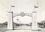
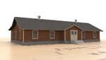
The airfield began life as far back as 1921 when it was home to DH.4's. In the days before the establishment of No. 5 EFTS, the airfield consisted of 3 Bessonneau Hangars, what I believe to be a hockey arena, and other buildings. It looked like this (pic from High River Town Hall):

In the WW2 years (much-quoted from Wiki) RCAF Station High River was a major participant in British Commonwealth Air Training Plan aircrew training. No. 5 Elementary Flying Training School (EFTS) was established at High River on 28 June 1941 after having moved from RCAF Station Lethbridge where the winds proved to be too strong for safe flying of the small trainers. Training was provided by civilian instructors from the Calgary Aero Club. De Havilland Tiger Moths were the first aircraft used up until late 1942. They were later replaced by Fairchild Cornells and the base was doubled in size with additional barracks and a second new hangar constructed. An unprepared emergency and practice landing field, also known as a relief landing field, was located on the then dry lakebed of nearby Frank Lake to the southeast. More than 4000 pilots were trained at No. 5 EFTS. The school closed on 15 December 1944.
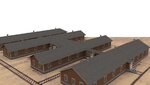
Below is a picture of how the base looked during the BCAPT days after 1943 when the base was expanded. As you can see, the 3 original hangars remained but the facilities were expanded with the addition of barracks, a recreation hall, and most obviously, the two larger hangars (pic also from the High River Town Hall):

A model and story board of the wartime base can be seen at the Bomber Command Museum of Canada in Nanton, Alberta:

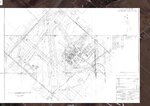
Here's an excerpt from an old map I found on line many years ago showing the operating area in and around the High River base. Someone has marked in apparent training zones for solo aerobatics, dual instruction, an "L.F. Area", and 4 "F.L.E." points, the meaning of which I don't know. Perhaps someone can provide clarity. The Station is located at top left with the emergency landing field at Frank Lake to the southeast. I have not yet looked into the two other nearby fields at Gladys and Ensign but Vulcan, at the bottom, will be the subject of a future post.

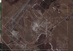
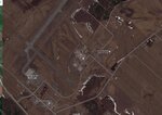
Following its closure, the base was largely dismantled and the only building remaining today is one of the two larger hangars which now serves as a manufacturing facility. Zooming in from above in Google Earth, the present day view features the only remaining hangar building and the faint hint of the former landing strips laid out in a triangle to the south, now used for agriculture.

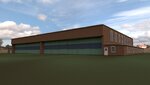
Seen at ground level, the remaining hangar building has obviously been updated


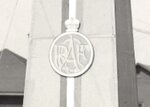
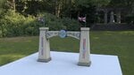
An addition has been built along the south wall and it appears that a steel truss was installed to reinforce the roof. A small memorial featuring an RCAF flag, bronze plaque, and a story board has been erected at the entrance road to this now-private facility.

That's all I have on this location. Again, if anyone wishes to make additions, please feel free!
The former airfield at High River, Alberta is just a 25 minute southbound scoot down the highway from where I live:
The airfield began life as far back as 1921 when it was home to DH.4's. In the days before the establishment of No. 5 EFTS, the airfield consisted of 3 Bessonneau Hangars, what I believe to be a hockey arena, and other buildings. It looked like this (pic from High River Town Hall):
In the WW2 years (much-quoted from Wiki) RCAF Station High River was a major participant in British Commonwealth Air Training Plan aircrew training. No. 5 Elementary Flying Training School (EFTS) was established at High River on 28 June 1941 after having moved from RCAF Station Lethbridge where the winds proved to be too strong for safe flying of the small trainers. Training was provided by civilian instructors from the Calgary Aero Club. De Havilland Tiger Moths were the first aircraft used up until late 1942. They were later replaced by Fairchild Cornells and the base was doubled in size with additional barracks and a second new hangar constructed. An unprepared emergency and practice landing field, also known as a relief landing field, was located on the then dry lakebed of nearby Frank Lake to the southeast. More than 4000 pilots were trained at No. 5 EFTS. The school closed on 15 December 1944.
Below is a picture of how the base looked during the BCAPT days after 1943 when the base was expanded. As you can see, the 3 original hangars remained but the facilities were expanded with the addition of barracks, a recreation hall, and most obviously, the two larger hangars (pic also from the High River Town Hall):
A model and story board of the wartime base can be seen at the Bomber Command Museum of Canada in Nanton, Alberta:
Here's an excerpt from an old map I found on line many years ago showing the operating area in and around the High River base. Someone has marked in apparent training zones for solo aerobatics, dual instruction, an "L.F. Area", and 4 "F.L.E." points, the meaning of which I don't know. Perhaps someone can provide clarity. The Station is located at top left with the emergency landing field at Frank Lake to the southeast. I have not yet looked into the two other nearby fields at Gladys and Ensign but Vulcan, at the bottom, will be the subject of a future post.
Following its closure, the base was largely dismantled and the only building remaining today is one of the two larger hangars which now serves as a manufacturing facility. Zooming in from above in Google Earth, the present day view features the only remaining hangar building and the faint hint of the former landing strips laid out in a triangle to the south, now used for agriculture.
Seen at ground level, the remaining hangar building has obviously been updated
An addition has been built along the south wall and it appears that a steel truss was installed to reinforce the roof. A small memorial featuring an RCAF flag, bronze plaque, and a story board has been erected at the entrance road to this now-private facility.
That's all I have on this location. Again, if anyone wishes to make additions, please feel free!