World War 2 in your backyard (1 Viewer)

Ad: This forum contains affiliate links to products on Amazon and eBay. More information in Terms and rules

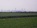
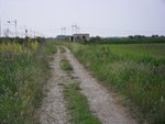
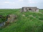
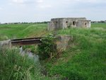
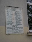
Tomorrow exactly 75 years ago, the Dutch army retreated rom the Grebbeline to the old, unmaintained 'Nieuwe Hollandse Waterlinie' near Utrecht. It was only fitting that I paced this place and saw this fort, build in 1820 and to be used again as part of the Waterlinie in 1940. No quality photos, I only had my iPod touch.
Image - 10 mei 2015 13.02.56.jpg
Image - 10 mei 2015 13.03.50.jpg
Image - 10 mei 2015 13.04.17.jpg
 
Great pics Marcel .
I hope you don't mind, but I've added one taken on my recent trip in the Tin Tent. This shows one of many WW2 defensive 'Pill Boxes' (center, right) still dotted around the British coastline, this example having collapsed from the side of the cliffs at Runswick Bay, five miles north of Whitby, on the east coast overlooking the North Sea.
 

Attachments

  • DSCF0096.JPG
    DSCF0096.JPG
    95.5 KB · Views: 217
Images of the Nieuwe Hollandse waterlinie between Nieuwegein and Houten.

Fort Vechten: Wonderful and enormous fort near Utrecht. Never knew it existed. Highly impressive and the nature is also great.
17739374485_7b67fe2569_c.jpg
20150516_0097 by Marcel Kerkveld, on Flickr

17736794662_12513d428f_c.jpg
20150516_0121 by Marcel Kerkveld, on Flickr

17551606038_1cdf111542_c.jpg
20150516_0123 by Marcel Kerkveld, on Flickr

17739724551_ae90f564d2_c.jpg
20150516_0077 by Marcel Kerkveld, on Flickr

Innundatie kanaal. This canal was ment to bring the water too the flooding area. The line exists of mostly flooded areas and fortifications where the water is too shallow. On the left you see the dyke belonging to the "gedekte gemeenschapsweg" or Sheltered community road. It's a road between 2 fortifications. The dyke proteted the troops against enemy fire and contains concrete shelters.
17553108839_3e2269a880_c.jpg
20150516_0057 by Marcel Kerkveld, on Flickr

The more modern "Werk aan de Groeneweg". Build first in 1918 and later modified in 1940. You can see the different types of troop shelters. The higher "Piramides" are the 1940 versions. It's a nice recreation area now and fun for the kids to play in the trenches and bunkers.
17551586418_11f74e3bfc_c.jpg
20150516_0025 by Marcel Kerkveld, on Flickr
 
Great thread Marcel! Here's my humble contribution...

I live in small town called Stara Pazova, which is located north of capitol city of Belgrade. Just one of many towns and villages lost in the fields of Srem region. Although German, Yugoslav and Soviet troops moved through here in 1941 and then again in 1944, luckily there wasn't any actual fighting in my town. However, the war did left some traces which still exist today.

Here are few pictures of one of those sites. It's a bunker which Germans build to guard and protect a small railroad bridge over an irrigation canal on the outskirts of town. Abandoned in 1944, it became a favorite playground for generations of kids after the war (myself included). The last two pictures are taken from new railroad bridge located nearby to the old one. Unfortunately this bunker is in rather poor condition nowadays.
 

Attachments

  • resize of SDC13833.JPG
    resize of SDC13833.JPG
    129 KB · Views: 240
  • resize of SDC13835.JPG
    resize of SDC13835.JPG
    179.2 KB · Views: 239
  • resize of SDC13837.JPG
    resize of SDC13837.JPG
    196.7 KB · Views: 222
  • resize of SDC13839.JPG
    resize of SDC13839.JPG
    213.7 KB · Views: 232
Last edited:
After the occupation of the country, the Srem region became part of the so called Independent State of Croatia (NDH). This building was a temporary seat of Gestapo and Ustashi offices and holding cells in my town. In November 1941 large group of Communists and resistant members were imprisoned and tortured here. Most of them were later executed in Sremska Mitrovica. Commemorative plaques on both sides of the entrance have the same text in Serbian and Slovak language with the list of people that were imprisoned here.
Today an elementary school is located in this building.
 

Attachments

  • resize of SDC13843.JPG
    resize of SDC13843.JPG
    195.2 KB · Views: 238
  • resize of SDC13844.JPG
    resize of SDC13844.JPG
    153.3 KB · Views: 254
  • resize of SDC13845.JPG
    resize of SDC13845.JPG
    157.9 KB · Views: 231
Last edited:
Okay, me again. It's starting to become a 'traces of ww2 in the Netherlands' thread, as I'm not confining myself to my backyard anymore (although I could post plenty of that as well).

This time, the beautiful island of Schiermonnikoog, one of the Frisian islands. I took my mother there last Saturday and of course visited some ww2 spots there. During the war, around 600 German soldiers stayed there on the little island. Mainly to mann the big radar station and for the rest they were Kriegsmarine personel. In May 1945, most of the members of the SD and gestapo i Groningen fled to the island, remaining there for another month, making this the last part of the Netherlands to be liberated on June 11th 1945.

Anyway, here some pictures:

Bunker Wassermann, meant to carry the big Wassermann-S radar antenna. The bunker is of the L-480 type, quite big. You can enter it freely.
water_DSCN0074.JPG

water_DSCN0088.JPG

water_DSCN0086.JPG

water_DSCN0077.JPG


A bunker containing a generator. Part of the Schlei project. The barrel is inside this bunker
water_DSCN0038.JPG

water_DSCN0041.JPG


Gun and some more bunker entrances in the dunes. The secod bunker is part of the Battery, operated by the KM. Inside a swallow had nested, he was not afraid of me as you can see. Had to use the flash on the camera as it was pitch dark in there
water_DSCN0049.JPG

water_DSCN0052.JPG

water_DSCN0054.JPG

water_DSCN0055.JPG

water_DSCN0056.JPG


Part of a Hallifax bomber that crashed in the Northsea, near Schiermonnikoog.
water_DSCN0073.JPG
 
This is one of the pillboxes quickly built at Blythburgh in 1940 on the Suffolk coast of Eastern England. In it you can see the concrete table for one of the two Vickers MMGs the local Home Guard platoon had allocated at a very early stage. It is here that my grandfather (veteran of South Africa and WW1) would have fought and died to delay any invading German troops. It's role was to delay troops coming just off the beach to both give time for the regular army to deploy and to locally give time for the bridge across the Blyth to be blown to isolate north south movements of a German invasion. It was a defence in depth. After the pillboxes had delayed the enemy by making them stop to deploy to destroy them, then the same would have been necessary for the loopholed village. After which the same situation would be repeated for the next village and so forth. There was an Auxilliary unit or two in the area but, of course, no one spoke of them.

Twin machine gun post, Blythbrough.JPG
2010_0512nmr0062.JPG
 

Users who are viewing this thread

Back